Grand Coulee
The land periodically uplifted and subsided over millions of years giving rise to some small mountains and, eventually, an inland sea.
From about 10 to 18 million years ago, a series of volcanic eruptions from the Grand Ronde Rift near the Idaho/Oregon/Washington/Montana border began to fill the inland sea with lava.
Large parts of northern North America were repeatedly covered with glacial ice sheets, at times reaching over 10,000 feet (3,000 m) in thickness.
The Purcell lobe blocked the Clark Fork River drainage, thus creating an enormous lake reaching far back into mountain valleys of western Montana.
The 500 cubic miles (2,100 km3) of water in Lake Missoula was released in just 48 hours—a torrential flood equivalent to ten times the combined flow of all the rivers in the world.
The deluge stripped away soil, cut deep canyons and carved out 50 cubic miles (210 km3) of earth, leaving behind areas of stark scabland.
In Oregon's Willamette Valley, as far south as Eugene, the cataclysmic flood waters deposited fertile soil and icebergs left numerous boulders from as far away as Montana and Canada.
Mountains of gravel as tall as 40-story buildings were left behind; boulders the size of small houses and weighing many tons were strewn about the landscape.
Early theories suggested that glaciers diverted the Columbia River into what became the Grand Coulee and that normal flows caused the erosion observed.
In the 1920s, J Harlen Bretz looked deeper into the landscape and put forth his theory of the dam breaches and massive glacial floods from Lake Missoula.
Archeological records date human presence back to nearly the end of the Ice Age, but the raging torrents erased the land of clear evidence, leaving us to question who, if anyone, may have survived.
Its unique characteristics include a lower floor at the head of the channel than at its outlet and the widest and highest dry falls cliff in the middle.
Encountering the steep slope of the monocline, the new river would have cascaded off the rim, 800 feet (240 m) down onto a broad plain where Coulee City and Dry Falls State Park now stand.
Northrup Canyon in Steamboat Rock State Park contains a dry cataract as wide as Niagara Falls and three times as high.
[7] Steamboat Rock, 880 feet (270 m) high and a 1 square mile (2.6 km2) in area, now stands as an isolated rise, but for a time it created two cataracts.
[7] The Lower Coulee tends along the monoclinal flexure to Soap Lake where the canyons end and the water flowed out into Quincy Basin.
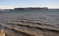
[8] The area surrounding the Grand Coulee is shrub-steppe habitat, with an average annual rainfall of less than twelve inches (300 mm).
The lake is filled by pumps from the Grand Coulee Dam and forms the first leg of a one-hundred-mile (160 km) irrigation system.