Cyclone Althea
After forming near the Solomon Islands on 19 December and heading southwest across the Coral Sea, the storm reached its peak intensity with 10-minute average maximum sustained winds of 130 km/h (80 mph) – Category 3 on the Australian cyclone scale.
Although early weather satellites provided only occasional glimpses into the cyclone's formative stages, its landfall was monitored closely by land-based radar that depicted an ongoing eyewall replacement cycle.
Althea produced copious rainfall over central and western Queensland as it turned toward the southeast, and on 26 December the cyclone emerged over open waters.
In the aftermath of the cyclone, 600 Australian Army soldiers aided recovery efforts in Townsville and Magnetic Island, while both state and federal governments contributed disaster relief funds.
Although little is known about the storm's genesis because of sparse reports and infrequent weather satellite images,[1] the disturbance is thought to have organised into a tropical low on 19 December as it tracked slowly southwestward into the Coral Sea.
[4] Near 18:00 UTC on 22 December, it reached its peak intensity with 10-minute maximum sustained winds of 130 km/h (80 mph); this made it a Category 3 severe tropical cyclone on the Australian scale.
[4] Late on 22 December, the eye remained obscured to satellite imagery by a canopy of cirrus clouds while the cyclone passed north of Lihou Reef.
[1][4] Althea likely continued to organise until landfall, which occurred at 23:00 UTC on 23 December – 09:00 AEST on Christmas Eve – near Rollingstone, about 50 km (30 mi) north of Townsville.
[1][5] Curving southeastward, Althea re-emerged over open waters between Maryborough and Double Island Point on 26 December and began to intensify once again.
[1] However, storm victims still criticised the agency and local radio news stations for unclear, untimely, or conflicting broadcasts that caused widespread confusion.
[13] About 100 people endured the cyclone in the dining room of a Picnic Bay hotel that ultimately sustained severe structural damage; 65 would remain sheltered there through Christmas Day.
[14] The island suffered a nearly total power outage, and after the water pipeline from the mainland was damaged, strict usage rations were put in place until repairs could be made.
[17] In the weeks following the cyclone's passage, further downpours plagued Townsville and triggered flooding when storm drains clogged with debris were unable to handle the runoff.
[30] Australian Prime Minister William McMahon soon traveled to Townsville to assess the damage and authorise the distribution of emergency grants for affected residents.
[33] About 600 Australian Army soldiers, including 130 engineers, were recalled from Christmas leave and stationed at Lavarack Barracks in Townsville for relief efforts around the area.
[10] In response to a request by Premier of Queensland Joh Bjelke-Petersen, the 1st Battalion, Royal Australian Regiment spent 10 days on Magnetic Island assisting in cleanup and recovery.
[14][30] Emergency vehicles, specialised personnel, electric generators, refrigerators, food rations, and other critical supplies were ferried to the island,[31] and medical officers rushed there to limit the spread of gastroenteritis after several cases were reported.
[34] To recognise the efforts of the Australian Army in the aftermath of Althea, a commemorative plaque was later erected in Townsville's Anzac Memorial Park.
[35] Initial recovery work was delayed by persistent flooding of roadways,[22] but within a few days of the cyclone, residents received around 2,000 tarpaulins to protect their damaged homes and building materials to begin repairs.
[29] By early January, the Royal Australian Air Force had airlifted 225,000 kg (500,000 lb) of emergency supplies into the Townsville area.
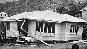
[37] Many of the damaged houses were of poor construction,[12] and in the wake of Althea, engineering studies of the destruction resulted in a new understanding of the structural design loads necessary to withstand severe winds.
[41] Three years later, Cyclone Tracy's devastation in Darwin, Northern Territory, bolstered the trend of more rigorous construction specifications in the country.
[38] Many of the buildings destroyed by Tracy were government housing units constructed according to new guidelines based on findings after Althea, showing the need for further study.
[13][42] Having seen the dangers of deficient construction first-hand, Townsville was the first community to enact the enhanced building standards, and served as a testing ground for further revisions.

Tropical storm (39–73 mph, 63–118 km/h)
Category 1 (74–95 mph, 119–153 km/h)
Category 2 (96–110 mph, 154–177 km/h)
Category 3 (111–129 mph, 178–208 km/h)
Category 4 (130–156 mph, 209–251 km/h)
Category 5 (≥157 mph, ≥252 km/h)
Unknown