Cyclone Dumazile
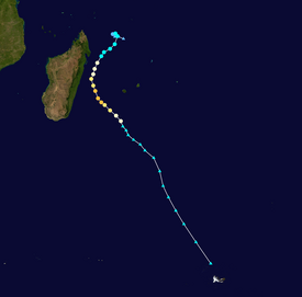
Dumazile originated from an area of low pressure that formed in the South-West Indian Ocean near Agaléga on 27 February.
Floodwaters, landslides, and downed trees caused significant damage and disruption to the road network on Réunion, particularly in coastal and mountainous areas.
Strong winds in coastal towns resulted in fallen trees, beach erosion, and damage to property and infrastructure.
A large region of unsettled weather along the Intertropical Convergence Zone spawned a broad area of low pressure in the South-West Indian Ocean near Agaléga on 27 February 2018.
[1][2] The system became more concentrated and well-defined as it drifted between Agaléga and Tromelin Island,[3] leading Météo-France La Réunion (MFR) to classify it as a Zone of Disturbed Weather at 00:00 UTC on 1 March.
[4][nb 1] That night increased thunderstorm activity in conjunction with an easterly wind burst furthered development,[6] and the MFR reported that the system became Tropical Disturbance 06 at 06:00 UTC on 2 March.
[7][nb 2] The incipient disturbance underwent a small clockwise loop over the rest of 2 March, amid opposing steering flows from the north and south.
The MFR noted the surrounding atmospheric environment to be quite conducive to strengthening, with low wind shear, high relative humidity values, and pronounced outflow channels.
[10] The JTWC stated that the system had become a tropical storm at 12:00 UTC on 2 March, as it began producing 1-minute sustained winds of 65 km/h (40 mph).
[7] The MFR also upgraded the system to a tropical storm at 00:00 UTC on 3 March, based on scatterometer data, upon which it received the name Dumazile.
[11] Modest strengthening ensued on 3 March as Dumazile began to move southwestward, in response to a developing ridge to its east.
[4] Microwave satellite imagery displayed a nascent eyewall on the evening of 4 March,[14] leading the MFR to assess that Dumazile had reached tropical cyclone strength by 18:00 UTC.
[4] An eye became increasingly apparent as Dumazile turned south-southeastward, while rounding the periphery of the ridge to its east, coinciding with significant strengthening through the morning of 5 March.
[7] Despite the cyclone's intensity, its eye remained somewhat oval in shape, likely due to interaction of the northwestern part of the circulation with the mountainous terrain of Madagascar.
[17] Dumazile's peak was short-lived, as weakening began almost immediately, with an increase in northwesterly wind shear over the system associated with an upper-level trough.
[18] The eye collapsed entirely on 6 March as Dumazile began interacting with the upper-level trough,[19] and the system fell back to severe tropical storm status by 18:00 UTC.
[4] Tropical cyclones passing close to Réunion in 2018, including Ava, Berguitta, Dumazile, and Fakir, caused a large reduction in the amount of mid- to upper-level clouds over the island.
[22] A combination of the Madden–Julian oscillation and tropical cyclones Dumazile, Eliakim, and Fakir resulted in a westward flow of moisture, causing severe rainfall over Kenya during March and April 2018.
[28] A section of the mountain road was covered in debris after a landslide occurred and strong waves submerged four lanes of the coastal highway with seawater.
[34] The ReNovRisk project utilized three seismic stations in the Salazie Basin to measure microseismic data and determine the level of sediment transport down a river.
Residents erected a temporary bridge using ladders to rescue 400 marooned people elsewhere in Cilaos and another 100 on a beach near Îlet Furçy.
[49] A trail from Bois Court and Grand Bassin was closed as a result of damage inflicted by cyclones Berguitta and Dumazile.
[50] The Dos d'Ane–Deux Bras hiking trail reopened on 17 July, after suffering damage during cyclones Berguitta, Dumazile, and Fakir.
[51] The RN5 highway was impassable for months at Îlet Furçy, after cyclones Ava, Berguitta, and Dumazile caused several landslides.
[56] Due to the threat of severe weather in Madagascar, a yellow alert was issued for the regions of Analanjirofo, Atsinanana, Diana, Sava, and Sofia, as well as the Farafangana, Nosy Varika, Manakara, Mananjary, Vohipeno,[57][58] and Mahajanga districts.
[73] Strong winds and heavy rains damaged homes, light poles, and metal sheeting from Toamasina to Ste Marie.
Long lines persisted for days outside gas stations as fuel became scarce; gasoline was rationed for safety reasons, to prevent storage in inappropriate containers.
Tropical storm (39–73 mph, 63–118 km/h)
Category 1 (74–95 mph, 119–153 km/h)
Category 2 (96–110 mph, 154–177 km/h)
Category 3 (111–129 mph, 178–208 km/h)
Category 4 (130–156 mph, 209–251 km/h)
Category 5 (≥157 mph, ≥252 km/h)
Unknown