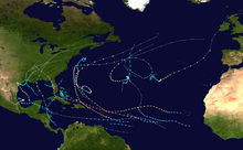
Tropical cyclones in 2017
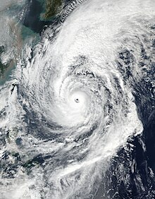
The strongest and deadliest tropical cyclone was Hurricane Maria with a minimum barometric pressure of 908 mbar (hPa; 26.81 inHg) and killing 3,000 people in Puerto Rico and Dominica.
Scientists pointed out that the increase of CO2 emissions contributes to warmer ocean waters and more moist air for rain.
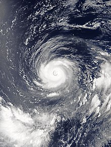
[6][5] Data collected by NASA showed that ocean surface temperatures in the path of Irma were above 30 °C (86 °F), capable of sustaining a Category 5 hurricane.
[7] Prior to affecting the U.S. mainland, Miami's mayor Tomás Regalado noted on Hurricane Irma, "This is the time to talk about climate change.
"[8] A day later the head of the EPA, Scott Pruitt said, "..to discuss the cause and effect of these storms, there's the… place (and time) to do that, it's not now.
"[9] Following Irma's landfall, Donald Trump was asked about the connection between hurricanes and climate change, and stated that "We’ve had bigger storms than this.
They asked several experts about their opinion, James Kossin from NOAA "There's no question that the storms are stronger than they were 30 years ago."
Meteorologist Philip Klotzbach noted, "What's happening with hurricanes — the frequency, the duration, and the energy — is probably a combination of factors caused by both nature and man, a mish-mosh of everything.
Due to the damage that the four hurricanes made, the names Harvey, Irma, Maria, and Nate were retired by the WMO after the season.
[16] In August, Hurricanes Franklin, Gert, Harvey, and Irma formed with the latter two causing catastrophic damage to the contiguous United States.
Harvey was also the wettest tropical cyclone ever recorded in the United States with a rainfall total of 60.58 inches in Nederland, Texas.
Along with the four systems, Irma also persisted through early September, making it and Maria the first Category 5 hurricanes to occur within the same month.
Selma became the first named storm to make landfall in El Salvador[20] and also contributed to the formation of Philippe in the Atlantic.
Tropical Depression Bising developed during the first week of February, and was a factor in, and worsened the effects of, the 2017 Visayas and Mindanao floods.
Torrential rainfall and strong winds from the cyclone itself and from the stormy weather that persisted for a number of days were responsible for major damage and 41 fatalities across mainland Japan.
Severe Tropical Storm Talas formed during mid-July near the Paracel Islands in the South China Sea, and traveled generally westwards.
It made landfall in Vietnam after brushing China's Hainan province and, unusually, continued to track far inland to the Laos–Thailand border before weakening to a depression.
Sonca brought heavy rainfall in Northeast Thailand and caused extreme flooding in the region with estimated costs of over US$300 million.
Typhoon Nesat and Tropical storm Haitang made landfall in Taiwan and Fujian (a province in China), respectively, 2 days apart.
In mid-late August, Typhoon Hato and Tropical Storm Pakhar made landfall in Macau and Guangdong respectively while they were at peak intensity.
So far Typhoon Hato is the costliest tropical cyclone in Northwest Pacific in 2017 with damages totalling $6.82 billion.
Typhoon Tembin was responsible for severe flooding and landslides in South Philippines, it became the deadliest tropical cyclone in 2017 with over 250 deaths.
Under the influence of strong monsoon surge a disturbance developed over Bay of Bengal travelled westwards and intensified to an unnamed depression.
A strong monsoon surge prevented formation of systems until a deep depression formed over West Bengal in October and caused heavy rainfall.
A couple of depressions formed between mid-October and November which continued the rain spell causing destruction of life and property.
Very Severe Cyclonic Storm Ockhi formed in early December and wreaked havoc in the countries where it impacted.
The twin storm of Ockhi was a deep depression which originated in Bay of Bengal while its counterpart was in Arabian Sea.
On the East Pacific, Hurricanes Eugene, Fernanda, Hilary and Irwin., a depression and Tropical Storm Greg formed.
In the Eastern Pacific, Hurricanes Otis, Max, Norma, and Tropical Storm Pilar existed during September.
In the Western Pacific, Tropical Storms Haikui and Kirogi existed during the month, affecting the Philippines and Indochina.