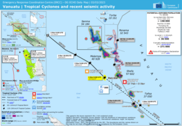
Cyclones Judy and Kevin
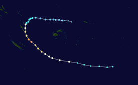
After continuous development from very warm sea surface temperatures, the system was classified as a tropical depression on the 26th by the Fiji Meteorological Service, shortly before the agency further upgraded its status to Category 1 the next day and assigned the name Judy to the storm.
On 28 February, Judy made landfall in Efate in Vanuatu before rapidly intensifying to a Category 4 severe tropical cyclone on 1 March.
[1] On 23 February, the Fiji Meteorological Service (FMS) reported that Tropical Disturbance 08F had developed about 130 km (80 mi) to the southeast of Halalo in Wallis and Futuna.
[2][4] Over the next couple of days, the system slowly moved westwards and gradually consolidated within a marginal environment for tropical cyclogenesis, with very warm sea surface temperatures of 29–30 °C (84–86 °F) being offset by moderate to high levels of vertical wind shear.
[6][7] At around 1100 VUT (00:00 UTC) on 27 February, the JTWC classified the depression as Tropical Cyclone 15P and initiated advisories on it, after they had received a bullseye ASCAT-B image which showed that winds of up to 65 km/h (40 mph) were occurring in the systems eastern quadrant.
[9][10] The cyclone then began to consolidate, with deepening central convection as it moved southwestward under the influence of a subtropical ridge to its southeast.
Turning southeastward, Judy further weakened into a Category 1-equivalent tropical cyclone, as unfavorable environment that consisted of cooling sea surface temperatures and high wind shear unraveled the storm's central convection.
[26] Three hours later, the JTWC reclassified Judy as a subtropical system, noting its central convection had been severely sheared to the southeast, partially exposing its low-level circulation center, along with significant erosion of its western peripheries due to an intrusion of a mid-level trough to its southwest.
[31][32] At that time, the low had a poorly organised low-level circulation center, however was improving as the environment for tropical cyclogenesis became more favorable, with 29–30 °C (84–86 °F) sea surface temperatures, moderate wind shear, and weak equatorial outflow aloft.
[33] Over the next day, the system progressed eastwards while gradually organizing, with its low-level circulation center being displaced to the east of deep convection.
[38] Moving east-southeast under the influence of a subtropical ridge in the same direction, Kevin intensified into a Category 2 tropical cyclone three hours later, as deep convection tightly wrapped its partially exposed low-level circulation center.
[41] The JTWC subsequently upgraded the system into a Category 1-equivalent tropical cyclone in the Saffir-Simpson scale three hours later, as a large central dense overcast (CDO) developed over its low-level circulation center.
[42] Owing to a favorable environment of warm sea surface temperatures, low wind shear and moderate radial outflow, Kevin intensified to a Category 2-equivalent tropical cyclone by the next day,[43] before undergoing a phase of rapid intensification.
[45] The JTWC subsequently upgraded the system to a Category 3-equivalent tropical cyclone three hours later, as it moved over Erromango and Tanna Island in Vanuatu,[46] before it cleared up a 21 nautical miles (39 km) eye, which made Kevin reach its peak intensity by 4 March.
[48] However, cooling sea surface temperatures and increasing wind shear made the system weaken to a Category 4-equivalent tropical cyclone nine hours later, as the storm's structure began to unravel on satellite imagery.
[59][60] Kevin's remnants were last noted in the MetService's bulletins on 11 March, before fully dissipating by the next day as it was absorbed by a warm front.
[61][62] On 26 February, the Solomon Islands Meteorological Service (SIMS) started to issue special weather bulletins, which warned that Judy was expected to cause gale-force winds, rough seas, moderate to heavy swells and costal flooding over southern parts of Temotu Province within 12 - 24 hours.
[64][65] Cyclone Judy impacted the Solomon Islands at the end of February while the system that became Kevin started affecting the nation soon after.
A small boat carrying passengers en route from Honiara to Central Province sank due to rough waves, but all of them managed to swim to safety.
[78] Cyclone Judy brought hurricane-force winds to Efate on 28 February,[72] and its eye passed directly over the capital city of Port Vila.
[81] Tropical Cyclone Judy has been bringing heavy rain and strong winds, and requiring the evacuation of residents from the capital, Port Vila.
As Cyclone Kevin was impacting the nation on 3 March, a Mw 6.5 earthquake struck just west of Espiritu Santo at a depth of 10 km (6.2 mi).
[86] On 28 February, New Zealand's MetService noted a risk of strong winds and large waves for New Caledonia as Cyclone Judy passed to the northeast.
[67] The Tonga Meteorological Service stated that the cyclones would likely remain far enough away to not have much impact; however, a small chance existed for Kevin to affect the kingdom.
[87] Although Kevin remained far to the south and west of Fiji on 3–4 March, associated inclement weather stemming from a trough prompted the issuance of heavy rain warnings for Ba, Kadavu, Lau, Lomaiviti, Nadroga-Navosa, and Ra provinces.
[67] Strong winds felled a royal poinciana tree in Naikabula, Ba Province, destroying a home in the process.
[90] After completion, it was noted that water sources had high turbidity and reservoirs in Tikopia were damaged by landslides caused by the tropical cyclones.
[81] Within two days, two C-17 Globemaster aircraft reached Port Vila carrying the initial supplies and a 12-person rapid response team.
Tropical storm (39–73 mph, 63–118 km/h)
Category 1 (74–95 mph, 119–153 km/h)
Category 2 (96–110 mph, 154–177 km/h)
Category 3 (111–129 mph, 178–208 km/h)
Category 4 (130–156 mph, 209–251 km/h)
Category 5 (≥157 mph, ≥252 km/h)
Unknown


Tropical storm (39–73 mph, 63–118 km/h)
Category 1 (74–95 mph, 119–153 km/h)
Category 2 (96–110 mph, 154–177 km/h)
Category 3 (111–129 mph, 178–208 km/h)
Category 4 (130–156 mph, 209–251 km/h)
Category 5 (≥157 mph, ≥252 km/h)
Unknown