Cyclone Yasa
Shipping services were halted, and fishermen were advised to not go out into sea, due to fears of Yasa possibly injuring or killing them.
The area of low pressure that would eventually become Severe Tropical Cyclone Yasa was first noted by the United States Joint Typhoon Warning Center (JTWC) during December 10, while it was located about 655 km (405 mi) to the north of Port Vila in Vanuatu.
[3] The system was also located within a marginally favourable environment for further development, with high levels of vertical wind shear, being offset by warm sea surface temperatures of around 29–30 °C (84–86 °F).
[3] During that day, the system gradually organized further as it moved south-eastwards, before it was classified as Tropical Disturbance 02F by the Fiji Meteorological Service (FMS) during December 11.
[9] Over the next day, the system continued to consolidate and absorbed Tropical Depression 01F, as it moved south-westwards along the northeastern edge of a subtropical ridge of high pressure.
[5][11] After it had been named, Yasa made a small anti-cyclonic loop, while its overall organisation improved significantly, with a compact eye feature appearing on microwave imagery.
[4][12] Yasa subsequently performed a second anti-cyclonic loop as the subtropical ridge weakened, while its primary steering mechanism started to change, which caused the system to move north-eastwards towards the Equator.
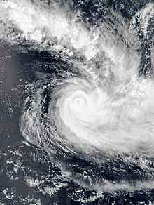
[5] During December 15, Yasa continued to rapidly intensify with its eye becoming well defined, before the FMS reported that the system had become the earliest Category 5 severe tropical cyclone on record.
[5][18][19] The JTWC reported that Yasa had peaked with 1-minute sustained wind speeds of 260 km/h (160 mph), which made it equivalent to a Category 5 hurricane on the SSHWS during December 16.
[24][25] The system subsequently moved into the Koro Sea, where it passed near or over several of the Lau Islands and started to interact with an upper-level trough of low pressure.
[25][26][27] Over the next couple of days, the system gradually weakened further, as it brushed Tonga, before it was classified as a former tropical cyclone by the FMS during December 19 as it degenerated into an extratropical low.
[4][30] During December 11, the FMS issued a gale warning for Rotuma, as Tropical Depression 01F was expected to impact the Fijian dependency, with wind gusts of up to 60 km/h (35 mph).
[41] The National Disaster Management Office posted on social media that storm surges with waves as high as 16 m (52 ft) were expected.
[45] On December 17, a nationwide curfew was enacted starting at 4:00 p.m local time[46] and the National Disaster Management Office declared a state of emergency.
[48] As the storm began to impact Vanuatu, a strong wind warning was put in effect for central and southern coastal areas of the country.
[50] Other regions of the country were forecast to experience torrential rainfall, swells up to 6 meters high, and violent storm force winds throughout the day.
[67] As with many disasters during the COVID-19 pandemic, recovery was anticipated to be much harder and slower due to restrictions and measures still needed to be taken while thousands remained in evacuation centers.
The funds of 86,000 Swiss Francs ($97,000 USD), were used to provide first aid, shelter materials, tarpaulins, hygiene kits, household items, and safe water to more than 17,700 people.
[72] The Australian Minister for Foreign Affairs Marise Payne released a statement on December 19 pledging that Australia would provide emergency humanitarian relief in whatever capacity possible with their condolences and thoughts with every person effected by the cyclone.
"[73][74] Australia's HMAS Adelaide, carrying personnel from the Australian Army's 6th Engineering Support Regiment and equipment was sent to assist Fiji in its recovery efforts.
The environmental NGO 350 in Fiji's secretary, Genevieve Jiva, said that Fijians are "literally fighting for our survival" after the storm's passing.

Tropical storm (39–73 mph, 63–118 km/h)
Category 1 (74–95 mph, 119–153 km/h)
Category 2 (96–110 mph, 154–177 km/h)
Category 3 (111–129 mph, 178–208 km/h)
Category 4 (130–156 mph, 209–251 km/h)
Category 5 (≥157 mph, ≥252 km/h)
Unknown