Cyclone Harold
Over the next day, the system moved south-eastwards over the Solomon Sea, before it was classified as a tropical cyclone and named Harold by the Australian Bureau of Meteorology.
It regained Category 5 severe tropical cyclone status (on the Australian scale only) while passing south of Fiji, before weakening and becoming extratropical on April 9.
[5] Thunderstorm activity began to coalesce about the centre later that day, and a nearby upper-level low directed the system southeast toward the Solomon Islands.
[8] The system subsequently crossed 160°E, where it moved out of the Australian region and into the South Pacific basin, which prompted the BoM to pass the primary warning responsibility to the Fiji Meteorological Service (FMS).
[9][10] As the storm moved away from the Solomon Islands on April 3, it began to rapidly organize and developed a pinhole eye on microwave imagery.
[13] At this time, Harold was located about 360 km (225 mi) to the northwest of Luganville in Vanuatu, and its southeast movement had slowed significantly as a result of an extension of a subtropical ridge to the storm's east.
[15][16] During April 5, the JTWC reported that the system had begun to weaken, based on the ragged structure of the eye and warming of the cyclone's cloud tops.
[16][17] However, this weakening phase was short-lived as the system regained a 30 km (20 mi) eye and a symmetric central dense overcast, while upper-level outflow remained strong.
[20] At this time, the system was located about 170 km (105 mi) to the west of Luganville and began to move polewards as a subtropical ridge to its northeast became the primary steering mechanism.
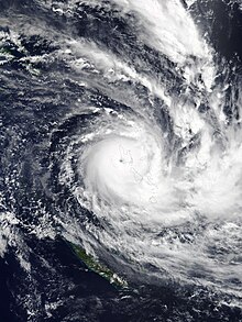
[22][23] Harold quickly strengthened upon reemerging over water; early the following day, the FMS reported that Harold had peaked in intensity with 10-minute sustained winds of 230 km/h (140 mph), while it was located between the islands of Espiritu Santo and Pentecost,[4] while the JTWC estimated that its 1-minute sustained winds reached 270 km/h (170 mph), which made it equivalent to a Category 5 hurricane on the SSHWS.
[25][26] As a result, the FMS reported that the system had weakened into a Category 4 severe tropical cyclone during April 7, before Harold's eye and eyewall became visible on their radar in Nadi.
[16] During April 8, the system intensified slightly before the FMS reported that Harold had become a category 5 severe tropical cyclone again, while it was located about 300 km (185 mi) to the north-east of Nuku'alofa on the Tongan island of Tongatapu.
[28][29] As the system continued to move south-eastwards, it passed about 115 km (70 mi) to the south of Nuku'alofa, as it started to weaken and transition into an extratropical cyclone.
[16][30] During the following day, Harold weakened into a Category 3 severe tropical cyclone as it moved into New Zealand's MetService area of responsibility, while strong vertical wind shear caused atmospheric convection to become displaced to the south of its eye.
[31][32] The JTWC subsequently issued its final advisory on Harold, as it was expected to gain frontal characteristics and complete its extratropical transition within 12 hours.
[32] MetService subsequently declared Harold to be an extratropical cyclone during April 10, before the system was last noted during the following day around 1,500 km (930 mi) to the southwest of Adamstown in the Pitcairn Islands.
[34] They warned that the system was expected to produce gale-force winds, rough seas, moderate to heavy swells of 2–4 metres (6.6–13.1 ft) and coastal flooding over the islands.
[43] On the night of April 2, the ferry MV Taimareho encountered rough seas and gusts of up to 80 km/h (50 mph) generated by Harold in Ironbottom Sound while en route from Taivu to the Aiarai in West Are 'are in Malaita Province.
[72] Beginning prior to landfall, the cyclone's slow movement west of Vanuatu drew in copious moisture, resulting in heavy rainfall.
[76] Water shortages and power outages began affecting Luganville, Espiritu Santo's largest city, prior to Harold's landfall.
[88] During April 6, the FMS issued a tropical cyclone alert for Viti Levu, Kadavu, Lomaiviti as well as the Yasawa and Mamanuca and Lau group of islands.
[89] The FMS issued heavy rain alerts for the western half of Viti Levu, Kadavu, and the Mamanuca and Yasawa islands on April 6, anticipating the arrival of Harold's rainbands and its centre's eventual passage south of Fiji.
[101] The director of the Fijian Ministry of Fisheries, Mere Lakeba, advised aquaculture farmers to reduce water usage and boaters to move their vessels to safety.
[128][129] A tornado struck Vusuya, Nausori on the morning of April 8, unroofing homes, uprooting trees, and felling power poles;[130] fifteen houses were badly damaged and two people were injured.
[88] The Fua’amotu Tropical Cyclone Warning Centre in Tonga was activated on April 7 as Harold was forecast to track into Tongan waters within two days.
[155] The center of Harold passed 90–100 km (56–62 mi) south of Tongatapu, lashing Tonga with heavy rains and wind; a peak gust of 80 km/h (50 mph) was registered at 'Eua Airport.
[158] Storm surge, reaching 0.86 m (2 ft 10 in) above king tide,[156] inundated coastal extents of Tongatapu,[159] with their greatest impacts on the island's central and western shores.
[40] Lisa Faerua, the country director for Oxfam, stated that recovery from the storm could take up to a year, which would likely be delayed as a result of the coronavirus pandemic.
[179] Between April 25 and 27, the Vanuatu Ministry of Health reported a significant increase in dengue fever and malaria cases in Torba and Sanma provinces, believed to be related to the cyclone.
[185] In the 2020 Bureau of Meteorology meeting, the name Harold was retired after the severe deaths and damage that it caused in the South Pacific basin, and was replaced with Heath for future seasons.

Tropical storm (39–73 mph, 63–118 km/h)
Category 1 (74–95 mph, 119–153 km/h)
Category 2 (96–110 mph, 154–177 km/h)
Category 3 (111–129 mph, 178–208 km/h)
Category 4 (130–156 mph, 209–251 km/h)
Category 5 (≥157 mph, ≥252 km/h)
Unknown