Cyclone Marcia
[3][4] The system drifted generally eastwards and developed slowly under moderate vertical wind shear, until the Joint Typhoon Warning Center (JTWC) issued a Tropical Cyclone Formation Alert early on 17 February when deep convection wrapping tightly into a well-defined centre.
[5] Late on the same day, the BoM began to issue technical bulletins and designated the tropical low as 14U, although the bureau initially forecasted that it would only intensify into a category 1 cyclone prior to landfall.
[7][8] When Marcia intensified into a category 2 tropical cyclone at 00:00 UTC on 19 February, it had developed a central dense overcast with a consolidating eyewall because of weakening vertical wind shear.
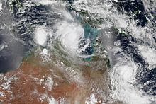
[11][12][13] Soon afterwards, it turned southwards along the western periphery of a subtropical ridge and reached peak intensity at 18:00 UTC as a category 5 severe tropical cyclone with 10-minute maximum sustained winds at 205 km/h (125 mph), featuring a very well-defined 35 km (20 miles) eye.
[16] On 20 February, despite good poleward outflow, Marcia began to track southeastwards along the western periphery of the subtropical ridge and rapidly weakened due to land interaction and increasing vertical wind shear, yet the JTWC issued the final warning during sunset.
[18][19][20] The BoM's final technical bulletin of Marcia indicated that the cyclone had eventually weakened into a tropical low at 15:00 UTC (01:00 AEST on 21 February), with the asymmetric wind structure and unimpressive observations.
[31] The Global Disaster Alert and Coordination System issued an advisory at 06:00 UTC on 20 February stating that up to 92,000 people had been affected by Category 1 winds or higher.
[33] Heavy rain fell across several regions and authorities evacuated residents from the small town of Jambin, south-west of Rockhampton, as localised flooding took place, which also affected Biloela.
The Bureau was criticised for continuing to report the ADT estimates after lower actual windspeeds had been recorded, by biologist and blogger Jennifer Marohasy of Central Queensland University.

Tropical storm (39–73 mph, 63–118 km/h)
Category 1 (74–95 mph, 119–153 km/h)
Category 2 (96–110 mph, 154–177 km/h)
Category 3 (111–129 mph, 178–208 km/h)
Category 4 (130–156 mph, 209–251 km/h)
Category 5 (≥157 mph, ≥252 km/h)
Unknown