Geography of Cyprus
[5] The rugged Troodos Mountains, whose principal range stretches from Pomos Point in the northwest almost to Larnaca Bay on the east, are the single most conspicuous feature of the landscape.
[4] Intensive uplifting and folding in the formative period left the area highly fragmented, so that subordinate ranges and spurs veer off at many angles, their slopes incised by steep-sided valleys.
[4] While the Troodos Mountains are a massif formed of molten igneous rock, the Kyrenia Range is a narrow limestone ridge that rises suddenly from the plains.
Even the highest peaks of the Kyrenia Range are hardly more than half the height of the great dome of the Troodos massif, Mount Olympus (1,952 m or 6,404 ft),[6] but their seemingly inaccessible, jagged slopes make them considerably more spectacular.
[4] The massive sulphide deposits formed as a part of an ophiolite complex at a spreading centre under the Mediterranean Sea which was tectonically uplifted during the Pleistocene and emplaced in its current location.
[4] The central Mesaoria plain is the agricultural heartland of the island, but its productiveness for wheat and barley depends very much on winter rainfall; other crops are grown under irrigation.
Over most of the island untilled ground bears a grazed covering of garrigue, largely composed of low bushes of Cistus, Genista sphacelata, Calicotome villosa, Lithospermum hispidulum, Phagnalon rupestre, and, locally, Pistacia lentiscus.
Where grazing is excessive this covering is soon reduced, and an impoverished batha remains, consisting principally of Thymus capitatus, Sarcopoterium spinosum, and a few stunted herbs.
[4] Hot, dry summers from mid-May to mid-September and rainy, rather changeable winters from November to mid-March are separated by short autumn and spring seasons.
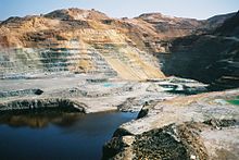
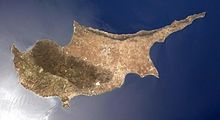
Area: Total: 9,251 km2 (of which 5,896 km2 (2,276 sq mi) are under the control of the Republic of Cyprus and of which 3,355 km2 (1,295 sq mi) are under military occupation by Turkey) Land: 9,241 km2 Water: 10 km2 Land boundaries: 0 km Coastline: 648 km Maritime claims: Territorial sea: 12 nmi (22.2 km; 13.8 mi) Continental shelf: 200 m depth or to the depth of exploitation Exclusive Economic Zone: 98,707 km2 (38,111 sq mi) Elevation extremes: Lowest point: Mediterranean Sea 0 m Highest point: Olympus 1,952 m[6] Natural resources: copper, pyrite, asbestos, gypsum, timber, salt, marble, clay earth pigment Land use: arable land: 9.90% permanent crops: 3.24% other: 86.86% (2012) Irrigated land: 457.9 km2 (2007) Total renewable water resources: 0.78 km3 (2011) Freshwater withdrawal (domestic/industrial/agricultural): total: 0.18 km3/yr (10%/3%/86%) per capital: 164.7 m3/yr (2009) Natural hazards: moderate earthquake activity; droughts Environment – current issues: water resource problems (no natural reservoir catchments, seasonal disparity in rainfall, sea water intrusion to island's largest aquifer, increased salination in the north); water pollution from sewage and industrial wastes; coastal degradation; loss of wildlife habitats from urbanization.