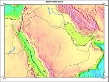
Geography of Saudi Arabia
Its extensive coastlines provide great leverage on shipping (especially crude oil) through the Arabian Gulf and the Suez Canal.
The undemarcated border became an issue in the early 1990s, when oil was discovered in the area and Saudi Arabia objected to the commercial exploration by foreign companies on behalf of Yemen.
[1] In 1922, Ibn Saud and British officials representing Iraqi interests signed the Treaty of Mohammara which established the boundary between Iraq and the future Saudi Arabia.
Forty-three years later, Saudi Arabia and Iraq signed an agreement that defined the border between the two countries and provided for the division of the neutral zone between them.
The boundary between Ibn Saud's territories of Najd and the Eastern Province and the British protectorate of Kuwait was first regulated by the Al Uqair Convention in 1922.
In an effort to avoid territorial disputes, another diamond-shaped Saudi–Kuwaiti neutral zone of 5,790 square kilometers directly south of Kuwait was established.
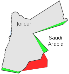
The border through 'Al Buraymi Oasis, located near the conjunction of the frontiers of Oman, Abu Dhabi (one of the emirates of the UAE) and Saudi Arabia, has triggered extensive dispute among the three states since the Treaty of Jeddah in 1927.
In a 1975 agreement with Saudi Arabia, Abu Dhabi accepted sovereignty over six villages in the 'Al Buraymi Oasis and the sharing of the rich Zararah oil field.
In recent years, these aquifers have been drawn upon heavily, both for agricultural and domestic purposes, and no fresh water remains in the lakes or pits.
In al-Ahsa numerous large, deep pools are constantly replenished by artesian springs as a result of underground water from the eastern watershed of the Jabal Tuwayq.
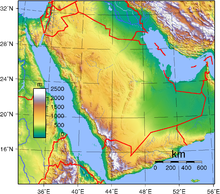
The Arabian Peninsula is an ancient massif composed of stable crystalline rock whose geologic structure developed concurrently with the Alps.
The Great Rift runs from the Mediterranean along both sides of the Red Sea south through Ethiopia and the lake country of East Africa, gradually disappearing in the area of Mozambique, Zambia, and Zimbabwe.
These fault lines are believed to be the northern and final portion of the Great Rift and are presumed to be the result of the slow rotation of the Arabian Peninsula counterclockwise in a way that will, in approximately ten million years, close off the Persian Gulf and make it a lake.
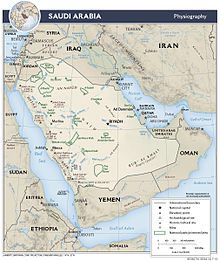
A long, narrow strip of desert known as Ad Dahna separates Najd from eastern Arabia, which slopes eastward to the sandy coast along the Persian Gulf.
The eastern slope of the mountain range in Asir is gentle, melding into a plateau region that drops gradually into the Rub al Khali.
Extensive lava fields (harrat) scar the surfaces of the plateaus east of the mountain ranges in the Hijaz and give evidence of fairly recent volcanic activity.
The largest of these beds is Khaybar, north of Medina; another is Al Harrah, part of the large volcanic field Harrat Ash Shamah.
[4] The rugged western face of the escarpment drops steeply to the coastal plain, the Tihamah lowlands, whose width averages 65 kilometers.
The heart of Najd is the area of the Jabal Tuwayq, an arc-shaped ridge with a steep west face that rises between 100 and 250 meters above the plateau.
This area, known as Badiyat ash Sham and covered with grass and scrub vegetation, is extensively used for pasture by nomadic and seminomadic herders.
The most significant feature of the area is the Wadi as Sirhan, a large basin as much as 300 meters below the surrounding plateau, which is the vestige of an ancient inland sea.
For thousands of years, some of the heavily traveled caravan routes between the Mediterranean and the central and southern peninsula have passed through the Wadi as Sirhan.
In the north is the Ad Dibdibah graveled plain and in the south the 'Al Jafurah sand desert, which reaches the gulf near Dhahran and merges with the Rub al Khali at its southern end.
Beneath the harsh deserts of Saudi Arabia lie dark chambers and complex mazes filled with crystalline structures, stalactites and stalagmites.
The limestone floor of the Summan plateau, a karst area to the east of the Dahna sands, is riddled with such caves, known locally as dahls.
Because the plants and animals of the sea floor are the basis of the food chain, damage to the shoreline has consequences for the whole shallow-water ecosystem, including the multimillion-dollar Saudi fisheries industry.
The spill had a severe impact on the coastal area surrounding Madinat 'al-Jubayl as Sinaiyah, the major industrial and population center newly planned and built by the Saudi government.
The soot from the Kuwaiti fires was found in the snows of the Himalayas and in rainfall over the southern members of the Community of Independent States, Iran, Oman, and Turkey.
Samples of soil and vegetation in Ras al Khafji in northern Saudi Arabia revealed high levels of particles of oily soot incorporated into the desert ecology.
Natural hazards: frequent sand and dust storms Environment - current issues: desertification; depletion of ground water resources; the lack of perennial rivers or permanent water bodies has prompted the development of extensive seawater desalination facilities; coastal pollution from oil spills Environment - international agreements: party to: Climate Change, Desertification, Endangered Species, Hazardous Wastes, Law of the Sea, Ozone Layer Protection Area: 2,250,000 km² (international borders of Saudi Arabia are not finalized.