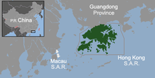
Geography of Hong Kong
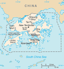
Hong Kong and its 260 nearby islands and peninsulas are located at the mouth of the Pearl River Delta.
Further from Victoria Harbour and the coast, the landscape of Hong Kong is fairly hilly to mountainous with steep slopes.
With the fourth-highest population density in the world at 6,300 people per square kilometre, Hong Kong is known for its shortage of residential space.
[2] The narrow body of water separating Hong Kong Island and Kowloon Peninsula, Victoria Harbour, is one of the deepest natural maritime ports in the world.
Hong Kong is 60 km (37 mi) east of Macau, on the opposite side of the Pearl River estuary.
Hong Kong's climate is subtropical and monsoonal (Köppen: Cwa), with cool dry winters and hot and wet summers.
It is surrounded by the South China Sea on all sides except the north, which neighbours the Guangdong city of Shenzhen along the Sham Chun River.
[5] The territory's highest point is Tai Mo Shan, 957 metres (3,140 feet) above sea level.
[6] Urban development is concentrated on the Kowloon Peninsula, Hong Kong Island, and in new towns throughout the New Territories.
[8] Undeveloped terrain is hilly to mountainous, with very little flat land, and consists mostly of grassland, woodland, shrubland, or farmland.
Concentrations of non-metalliferous minerals that have been commercially exploited include kaolin clay, feldspar, quartz, beryl and graphite.
[15] For many years, granite and volcanic rocks have been quarried locally for road base metal, riprap, armour stone and asphalt, although the main purpose now is for concrete aggregates.
Figures published by the United States Central Intelligence Agency[1] Big 22 Tropical cyclones are frequent in Hong Kong during the summer months between June and August.