Dirk Hartog
Born into a seafaring family, he received his first ship's command at the age of 30 and spent several years engaged in successful trading ventures in the Baltic and Mediterranean seas.
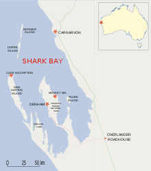
Hartog then set off across the Indian Ocean for Batavia (present-day Jakarta), utilising (or perhaps blown off course by) the strong westerly winds known as the "Roaring Forties" which had been noted earlier by the Dutch navigator Hendrik Brouwer as enabling a quicker route to Java.
Its inscription (translated from the original Dutch) read: Finding nothing of interest, Hartog continued sailing northwards along this previously uncharted coastline of Western Australia, making nautical charts up to about 22° latitude south.
In his journal, Houtman identified these coasts with Marco Polo's land of Beach, or Locach, as shown on maps of the time such as that of Petrus Plancius and Jan Huyghen van Linschoten.
[6][7] Eighty years later, on 4 February 1697, the Dutch explorer Willem de Vlamingh landed on the island and by chance found the Hartog plate, which lay half-buried in sand.