Dnipropetrovsk Oblast
The Black Sea Lowland covers about half of the territory of the oblast, where it lies only within the west bank of the Dnieper.
[7] The Dnieper Upland contains a number of minerals including iron, manganese, granite, graphite, brown coal, and kaolin.
Most of them are located in Kryvyi Rih itself, which is the longest city in Europe (roughly 67 km (42 mi) in a straight line from one end to another).
Much of the Dnipropetrovsk oblast is located within the boundaries of the Ukrainian Shield and only the northern regions and the extreme eastern part of the territory are confined to the south-eastern side of the Dnipro-Donets depression.
In the geological structure of the region, the breeds come from the archaea,[clarification needed] the Proterozoic, the Paleozoic, the Mesozoic and the Cenozoic.
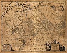
During the period of Kievan Rus' (9th to 12th centuries AD) the Dnieper River functioned as one of the main trade corridors of medieval Eastern Europe, part of the route "from the Varangians to the Greeks", which connected the Baltic Sea region with the Crimea and with the capital of Byzantium, Constantinople.
The Dnieper also served as a major route for transporting the armies of Kyiv princes on their way to the Byzantine coastal cities in the early 9th and late 9th centuries.
[9][10] At the beginning of the 15th century, Tatar tribes inhabiting the right bank of the Dnieper were driven away by the Grand Duchy of Lithuania.
[citation needed] The Grand Duchy of Lithuania and the Crimean Khanate agreed to a border along the Dnieper, and farther east along the Samara River, i.e. through what is today the city of Dnipro.
At this time there appeared a new force, the Cossacks - armed free men not subject to any feudal lord - who soon came to dominate the region.
This period of raids and fighting caused considerable devastation and depopulation in the Pontic steppe; the area became known as the "Wilderness" or the "Wild Fields".
In 1635, the Polish government built the Kodak fortress above the Dnieper Rapids at Kodaky, partly as a result of rivalry in the region between Poland, Turkey and the Crimean Khanate,[11] and partly to maintain control over Cossack activity (i.e. to suppress the Cossack raiders and to prevent peasants moving out of the area).
[12] On the night of 3 or 4 August 1635, the Cossacks of Ivan Sulyma captured the fort by surprise, burning it down and butchering the garrison of about 200 West European mercenaries under Jean Marion.
[12] The fort, rebuilt by French engineer Guillaume Le Vasseur de Beauplan[13] for the Polish government in 1638, had a mercenary garrison.
On 1 August 1925, the Yekaterinoslav Governorate administration was discontinued, and in 1926 the city of Yekterinoslav was renamed Dnipropetrovsk after Ukrainian Soviet leader Grigory Petrovsky.
[19] Before the introduction of oblasts in 1932, the Ukrainian SSR comprised 40 okrugs, which had replaced the former Russian Imperial guberniya (governorate) subdivisions.
The oblast's administrative centre and largest city, Dnipro, had had the unofficial name "Sicheslav" (commemorating the Zaporizhian Sich) in 1918–21 during the Ukrainian War of Independence.
[25] Since then, the renaming process has stalled (as of 2023[update]), for reasons such as the 2019 presidential and parliamentary elections, the COVID-19 pandemic and the Russian invasion of Ukraine (2022 onwards).
The oblast has one of the most balanced percentage of religious people in the nation mainly due to large number of ethnic groups.
Major population centers today result from historical factors — with the advent of the iron development took place predominantly along the Kryvyi Rih and Dnipro, a city located on the Dnieper.
CDR's route map includes all the railroads in the Dnipropetrovsk, Zaporizhzhia, Kharkiv, Kherson oblasts and the Autonomous Republic of Crimea.
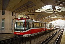
More than a dozen elektrichka stops are located within the city allowing residents of different neighborhoods to use the suburban trains.
The cities of Dnipro and Kryvyi Rih are served by a local sales-tax-funded bus, tram, metro and trolleybus systems.
The tender climate, mineral sources, and the curative mud allow opportunities for rest and cure within the region.
Many sewing and dress-making factories work for France, Canada, Germany and Great Britain [citation needed], using the most advanced technologies, materials and design.
Being a business oligarch entity, Privat Group controls some prominent Ukrainian media, maintains close relations with politicians and sponsors professional sports.
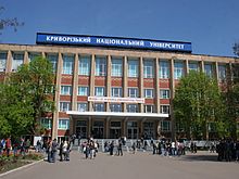
The oblast has several colleges and universities: Region houses the Ukrainian Premier League football club, FC Dnipro.
The club's owner is the Kryvyi Rih Iron Ore Combine (KZRK), the biggest subterranean mining public company in Ukraine.
[citation needed] Historically, this region is tightly entwined with the history of Ukraine and is considered the heart of the country.
In 2002 was adopted flag and identical coat of arms of Oblast, which consists of cossack with musket and nine yellow eight-pointed stars.