European maritime exploration of Australia
[13][14][16][15]: section III.B On 26 February 1606, Janszoon and his party made landfall near the modern town of Weipa and the Pennefather River, but were promptly attacked by the Indigenous people.
At the final place, he initially had friendly relations with the natives, but after he forced them to hunt for him and appropriated some of their women, violence broke out and there were many deaths on both sides.
The problem with the route, however, was that there was no easy way at the time to determine longitude, making Dutch landfalls on the west coast of Australia inevitable, as well as ships becoming wrecked on the shoals.
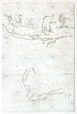
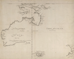
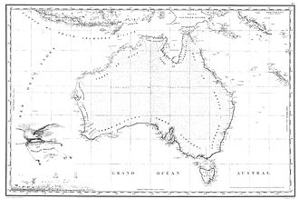
Finding nothing of interest, Hartog continued sailing northwards along this coastline of Western Australia previously unknown to Europeans, making nautical charts up to about 22° latitude south.
On 1 May 1622, Englishman John Brooke in the Tryall, a British East India Company owned vessel of approximately 500 tons, on the way to Batavia made the second English voyage to use Brouwer's southern route.
[28][29] In March 1622, the Dutch galleon Leeuwin, captained by Jan Fransz, mapped parts of the Australian coast between Hamelin Bay and Point D'Entrecasteaux.
In 1623, Jan Carstensz was commissioned by VOC to lead an expedition to the southern coast of New Guinea and beyond, to follow up the reports of further land sighted by Janszoon in his 1606 voyages to the south.
[30] Landing in search of fresh water for his stores, Carstensz encountered a party of the local indigenous Australian inhabitants, who he described as "poor and miserable looking people" who had "no knowledge of precious metals or spices".
[31] In August 1642, VOC despatched Abel Tasman and Franchoijs Visscher on a voyage of which one of the objects was to obtain knowledge of "all the totally unknown provinces of the kingdom of Beach".
From the point of view of the Dutch East India Company, Tasman's explorations were a disappointment: he had found neither a promising area for trade nor a useful new shipping route.
[35] This geographical achievement was displayed on the large world map Nova Totius Terrarum Orbis Tabula made by the Dutch cartographer Joan Blaeu in 1648 to commemorate the Peace of Westphalia.
[36][37] Based on Joan Blaeu's Nova et Accuratissima Terrarum Orbis Tabula ("A New and Most Accurate Chart of the Sphere of the Earth") of the same year, it incorporated Tasman's discoveries.
[38] Maps from this period and the early 18th century often have Terra Australis or t'Zuid Landt ("the South Land") marked as "New Holland", the name given to the continent by Abel Tasman in 1644.
This western limit of Spain's claim is shown on the 1761 map of the Spanish Empire by Vicente de Memije, Aspecto Symbolico del Mundo Hispanico ("Symbolic Presentation of the Spanish World")[45] and played a part in the British claim and division of the territory during the establishment of New South Wales in the late 18th century and Western Australia in the early 19th century.
In 1696, Willem de Vlamingh commanded the rescue mission to Australia's west coast to look for survivors of the Ridderschap van Holland that had gone missing two years earlier.
The mission proved fruitless, but along the way Vlamingh charted parts of the continent's western coast and as a result improved navigation on the Indian Ocean route from the Cape of Good Hope to the Dutch East Indies.
After a stay in South America and the Falklands, Bougainville reached Tahiti in April 1768, where his boat was surrounded by hundreds of canoes filled with beautiful women.
With his men weak from scurvy and disease and no way through he sailed for Batavia in the Dutch East Indies where he received news of Wallis and Carteret who had preceded Bougainville.
In the meantime, in 1768, British Lieutenant James Cook was sent from England on an expedition to the Pacific Ocean to observe the transit of Venus from Tahiti, sailing westwards in HMS Endeavour via Cape Horn and arriving there in 1769.
The leader turned back but the second in command, Louis Aleno de St Aloüarn, sighted Cape Leeuwin and followed the Western Australian coast north to Shark Bay.
On the first occasion, in 1773, Furneaux explored a great part of the south and east coasts of Van Diemen's Land, and made the earliest British chart of the same.
Phillip had decided to move the settlement to Sydney Cove in Port Jackson, but the British ships were unable to leave Botany Bay until 26 January because of a tremendous gale.
[59] La Pérouse was 6 weeks in Port Jackson, where the French established an observatory,[62] held Catholic masses,[63] performed geological observations,[64] and planted the first garden.
[65] Before leaving Sydney on 10 March, La Pérouse took the opportunity to send his journals, some charts and also some letters back to Europe with a British naval ship from the First Fleet—the Alexander.
Élisabeth Rossel, the most senior surviving officer, sailed from Java in January 1795 on board a Dutch ship taking with him the expedition's papers.
[69] In 1796 (after settlement), British Matthew Flinders with George Bass took a small open boat, the Tom Thumb 1, and explored some of the coastline south of Sydney.
[11] He had two ships, Géographe and Naturaliste captained by Jacques Hamelin, and was accompanied by nine zoologists and botanists, including Jean Baptiste Leschenault de la Tour.
In Sydney he bought a new ship, the Casuarina, a smaller vessel which could conduct close inshore survey work, under the command of Louis de Freycinet.
According to researchers from the University of Adelaide, during this expedition Baudin prepared a report for Napoleon on ways to invade and capture the British colony at Sydney Cove.
In response, the Lady Nelson and the whaler Albion, both under direction of Lieutenant John Bowen, sailed from Port Jackson on 31 August 1803 to establish a settlement in Van Diemen's Land, and on 10 October 1803 a convoy of two ships HMS Calcutta and Ocean led by Captain David Collins carrying 402 people entered Port Phillip and formed a settlement near Sorrento.