Figure of the Earth
Several models with greater accuracy (including ellipsoid) have been developed so that coordinate systems can serve the precise needs of navigation, surveying, cadastre, land use, and various other concerns.
While it is the surface on which Earth measurements are made, mathematically modeling it while taking the irregularities into account would be extremely complicated.
The Pythagorean concept of a spherical Earth offers a simple surface that is easy to deal with mathematically.
For surveys of small areas, a planar (flat) model of Earth's surface suffices because the local topography overwhelms the curvature.
By the late 1600s, serious effort was devoted to modeling the Earth as an ellipsoid, beginning with French astronomer Jean Picard's measurement of a degree of arc along the Paris meridian.
Improved maps and better measurement of distances and areas of national territories motivated these early attempts.
In the mid- to late 20th century, research across the geosciences contributed to drastic improvements in the accuracy of the figure of the Earth.
The primary utility of this improved accuracy was to provide geographical and gravitational data for the inertial guidance systems of ballistic missiles.
This funding also drove the expansion of geoscientific disciplines, fostering the creation and growth of various geoscience departments at many universities.
[1] These developments benefited many civilian pursuits as well, such as weather and communication satellite control and GPS location-finding, which would be impossible without highly accurate models for the figure of the Earth.
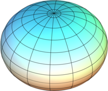
As theorized by Isaac Newton and Christiaan Huygens,[3]: 4 the Earth is flattened at the poles and bulged at the equator.
(semi-minor axis) The possibility that the Earth's equator is better characterized as an ellipse rather than a circle and therefore that the ellipsoid is triaxial has been a matter of scientific inquiry for many years.
[3] More recent results indicate a 70 m difference between the two equatorial major and minor axes of inertia, with the larger semidiameter pointing to 15° W longitude (and also 180-degree away).
Following work by Picard, Italian polymath Giovanni Domenico Cassini found that the length of a degree was apparently shorter north of Paris than to the south, implying the Earth to be egg-shaped.
[3]: 4 In 1498, Christopher Columbus dubiously suggested that the Earth was pear-shaped based on his disparate mobile readings of the angle of the North Star, which he incorrectly interpreted as having varying diurnal motion.
[8] The theory of a slightly pear-shaped Earth arose when data was received from the U.S.'s artificial satellite Vanguard 1 in 1958.
[3]: 9 Potential factors involved in this aberration include tides and subcrustal motion (e.g. plate tectonics).
[9][10] John A. O'Keefe and co-authors are credited with the discovery that the Earth had a significant third degree zonal spherical harmonic in its gravitational field using Vanguard 1 satellite data.
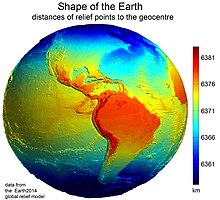
It was stated earlier that measurements are made on the apparent or topographic surface of the Earth and it has just been explained that computations are performed on an ellipsoid.
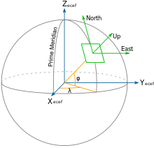
The latter is particularly important because optical instruments containing gravity-reference leveling devices are commonly used to make geodetic measurements.
When properly adjusted, the vertical axis of the instrument coincides with the direction of gravity and is, therefore, perpendicular to the geoid.
This concept aids the interpretation of terrestrial and planetary radio occultation refraction measurements and in some navigation and surveillance applications.
According to theoretical arguments by Newton, Leonhard Euler, and others, a body having a uniform density of 5,515 kg/m3 that rotates like the Earth should have a flattening of 1:229.
[17] However, the measured flattening is 1:298.25, which is closer to a sphere and a strong argument that Earth's core is extremely compact.
Therefore, the gross structure of the Earth's crust and mantle can be determined by geodetic-geophysical models of the subsurface.