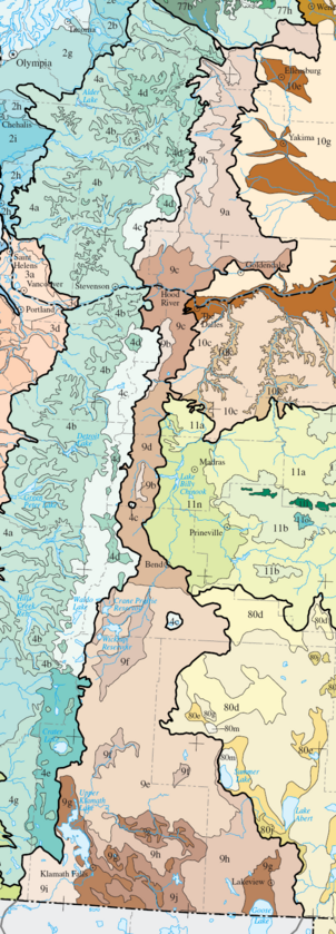
Eastern Cascades Slopes and Foothills
The dry continental climate supports open woodlands dominated by ponderosa pine and bitterbrush, with some Douglas-fir and Oregon white oak.
The frigid soils and snowy, continental climate support a mix of grand fir and Douglas-fir, with some ponderosa pine and western larch.
[1][2] The Oak/Conifer Foothills ecoregion is lower and drier than the Grand Fir Mixed Forest and more diverse than other parts of the Eastern Cascades.
Understory plants include Idaho fescue, bluebunch wheatgrass, antelope bitterbrush, Oregon grape, hazel, and snowberry.
Common land uses include forestry, recreation, grazing, rural residential development, orchards, and, in the valleys, grain and hay farming.
[1][2] The Ponderosa Pine/Bitterbrush Woodland ecoregion has a terrain dominated by high, undulating volcanic plateaus and canyons, with permanent, medium gradient streams.
The region covers 1,077 square miles (2,790 km2) in Oregon, east of Mount Jefferson, Three Fingered Jack, and the Three Sisters, in the Deschutes National Forest and on the Warm Springs Indian Reservation.
Residual soils are very deep, highly permeable, and subject to drought, with intermittent, low to medium gradient streams and spring-fed creeks and marshes.
Colder depressions and flats, where pumice deposits are thickest, are dominated by lodgepole pine, with an understory of antelope bitterbrush and Idaho fescue.
The Pumice Plateau is the largest of the Eastern Cascades subregions, covering 4,236 square miles (10,970 km2) in Oregon between Bend and Klamath Falls.
The La Pine Basin is underlain by thick lacustrine deposits that exhibit high groundwater levels during the spring snowmelt.
Marshes, lakes, reservoirs, wetland forests, and medium and low gradient rivers provide important habitat for migratory waterfowl.
A variety of wildrye, bluegrass, and wheatgrass species once covered the basins, but most of the wet meadows and wetlands have been drained for rural residential development, pasture, and cropland, including alfalfa, potatoes, and small grains.
[1][2] The Fremont Pine/Fir Forest ecoregion contains steeply to moderately sloping mountains and high plateaus that rarely exceed timberline.
Understory plants include snowberry, heartleaf arnica, Wheeler bluegrass, antelope bitterbrush, and longstolon sedge.
The region covers 515 square miles (1,330 km2) in Oregon, south of Aspen Butte in the Klamath River watershed, including Bear Valley National Wildlife Refuge.
Several species found in the shrub-steppe grasslands are uncommon in eastern Oregon, such as woolly wyethia, Klamath plum, and birchleaf mountain-mahogany.
The region covers 784 square miles (2,030 km2) in Oregon, south of Klamath Falls in the Lost River watershed, a mixture of public and private land.