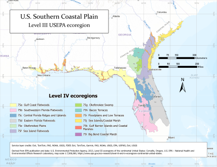
Southern Coastal Plain (ecoregion)
The North American Southern Coastal Plain is a Level III ecoregion designated by the Environmental Protection Agency (EPA) in six U.S. states.
Mostly flat plains, the region also includes barrier islands, coastal lagoons, marshes, and swampy lowlands along the Gulf and Atlantic coasts.
[1]Common species of the Southern Coastal Plain ecoregion include black bear, white-tailed deer, bobcat, marsh rabbit, fox squirrel, manatee, egret, blue heron, red-cockaded woodpecker, indigo bunting, Florida scrub jay, box turtle, gopher tortoise, southern dusky salamander, scrub lizard, cottonmouth, and alligator.
[1] Human land uses of this region include pine plantations and forestry, pasture for beef cattle, citrus groves, tourism and recreation, and fish and shellfish production.
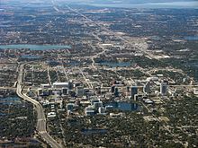
Larger cities from north to south include Georgetown, Charleston, Savannah, Waycross, Brunswick, Jacksonville, Hammond, Slidell, Gulfport, Biloxi, Pascagoula, Mobile, Pensacola, Gainesville, Ocala, Orlando, Tampa, St. Petersburg, and Fort Myers.
[1] In Louisiana, Mississippi, and Alabama, the Gulf Coast Flatwoods is a narrow region of nearly level terraces and delta deposits composed of Quaternary sands and clays.
[4] In Florida, the Gulf Coast Flatwoods expand into a wider area, which borders the central uplands (75c) on the east, sharing the same southern terminus as the Big Bend Coastal Marsh (75l) just north of Tampa.
Settlements in the Gulf Coast Flatwoods include Hammond, Slidell, Gulfport, Biloxi, Mobile, Pensacola, and Panama City.
The Southwestern Florida Flatwoods are a relatively large region of flat topography, sandy soils, and pine scrub dominated by saw palmetto, with pockets of wetland.
[8] Settlements in the Southwestern Florida Flatwoods include Tampa, Clearwater, St. Petersburg, Sarasota, Port Charlotte, Cape Coral, Lehigh Acres, Immokalee, and the coastal edges of Bonita Springs and Naples.
The ridge is primarily composed of xeric upland sands, falling into adjacent, poorly draining flatwoods (75b and 75d) on either side, averaging 11.7 kilometres (7.3 mi) in width.
[7][9] The Eastern Florida Flatwoods are a region extending from Lake Okeechobee in the south to the St. Johns River estuary in the north, though not quite so far as Jacksonville.
With Trail Ridge at its eastern boundary, the swamp drains to the south and southwest and contains the headwaters for the St. Marys and Suwannee Rivers.
Cypress, blackgum, and bay forests are common, with scattered areas of prairie, which are composed of grasses, sedges, and various aquatic plants.
[13] Maritime forests of live oak, red cedar, slash pine, and cabbage palmetto grow on parts of the sea islands, and various species of cordgrass, saltgrass, and rushes are dominant in the marshes.
The coastal marshes, tidal creeks, and estuaries are important nursery areas for fish, crabs, shrimp, and other marine species.
During the colonial and antebellum periods in the 1700s and 1800s, a plantation agriculture economy dominated the region, producing rice, indigo, and Sea Island cotton.
While parts of the this region are now managed as wildlife refuges or estuarine research reserves, the expanding resort economy continues to broadly change land uses, water quality, and the once more isolated Gullah and Sea Island cultures.
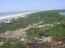
Cordgrass and saltgrass are common in the intertidal zone, while xeric coastal strand and pine scrub vegetation occurs on parts of the dunes, spits, and barrier islands.
[17] The Big Bend Coastal Marsh generally transitions to the Gulf Coast Flatwoods (75a), which may be piney forest or swamp depending on inflow of freshwater and soil drainage.
Adjacent swamps, and the coastal marsh in general, are very sensitive to tidal flooding (and baseline sea level rise), saltwater intrusion, aquatic pollution, tropical cyclones, and cold snaps (whose frequency has increased due to anthropogenic climate change).