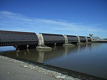
Eider Barrage
Following the North Sea flood of 1962 which swept through Tönning, consideration was given to raising the dykes along the banks of the Eider or building a storm surge barrier at its mouth.
The current conditions in the estuary caused great difficulties and the cost of construction was correspondingly high (ca.
The new current conditions however dug a new hole about 30 metres deep directly in front of the dyke and lock which had to be filled in during the 1980s with 20,000 sandbags.
48,000 geotextile containers (sand bags made of a special material) at a rate of ca.
Above the tunnel is a footpath, which offers a good view of the west coast and the river Eider.
The construction of the barrage resulted in the old Eider estuary becoming the Katinger Watt nature reserve; on the opposite side of the river in 1989 the Dithmarscher Eiderwatt was established in order to at least partially compensate for the losses of salt meadows and mudflats caused by the building of the barrage.