Elizabeth Lake (Los Angeles County, California)
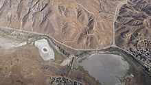
Elizabeth Lake is a natural sag pond that lies directly on the San Andreas Fault in the northern Sierra Pelona Mountains, in northwestern Los Angeles County, southern California.
[5] Elizabeth Lake once marked a dividing point between the territories of the Tataviam, Kitanemuk, and Serrano tribes of Native Americans.
Another inland route diverged from the El Camino Viejo at Elizabeth Lake, going north to cross the western Antelope Valley and then up Cottonwood Creek canyon, to cross over the Tehachapi Mountains via Old Tejon Pass, and down Tejon Creek canyon to the San Joaquin Valley.
[9] From 1849 to before 1854, it was the main road connecting the southern part of the state to the trail along the eastern side of the San Joaquin Valley to the goldfields to the north.
[10] The Mexican land grant Rancho La Liebre was established in 1846 in Alta California, with its southeastern section in the Sierra Pelona Mountains near the lake.
In the early 1850s, the vicinity of La Laguna de Chico Lopez was a frequent haunt of California grizzly bears—so numerous that cattle ranching was considered impossible.
The San Andreas fault line is mapped as passing about 8 miles north of these springs, and its proximity suggests that the existence of the warm water may be due to subsidiary fracturing of the rocks.