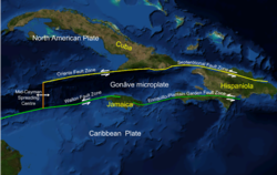
Cayman Trough
[2] This system continues on until the Chiapas massif where it is part of the diffuse triple junction of the North American, Caribbean and Cocos plates.
[3] The relatively narrow trough trends east-northeast to west-southwest and has a maximum depth of 7,686 metres (25,217 ft).
Within the trough is a slowly spreading north–south ridge which may be the result of an offset or gap of approximately 420 kilometres (260 mi) along the main fault trace.
[4] The western section of the trough is bounded to its south by the Swan Islands Transform Fault.
[6][failed verification] In 2010 a UK team from the National Oceanography Centre in Southampton (NOCS), equipped with an autonomously controlled robot submarine, began mapping the full extent of the trench and discovered black smokers on the ocean floor at a depth of 5 km (16,000 ft), the deepest yet found.