Funan
Funan (Chinese: 扶南; pinyin: Fúnán; Khmer: ហ៊្វូណន, romanized: Hvunân, Khmer pronunciation: [fuːnɑːn]; Vietnamese: Phù Nam, Chữ Hán: 夫南; Sanskrit: व्याधपूर, Vyādhapūra) was the name given by Chinese cartographers, geographers and writers to an ancient Indianized state—or, rather a loose network of states (Mandala)[1][2]—located in Mainland Southeast Asia covering parts of present-day Cambodia, Thailand and Vietnam that existed from the first to sixth century CE.
Though regarded by Chinese authors as a single unified polity, some modern scholars suspect that Funan may have been a collection of city-states that sometimes were at war with one another and at other times constituted a political unity.
[6] From archaeological evidence, which includes Roman, Chinese, and Indian goods excavated at the ancient mercantile centre of Óc Eo in southern Vietnam, it is known that Funan must have been a powerful trading state.
Though treated by Chinese historians as a single unified empire, according to some modern scholars Funan may have been a collection of city-states that sometimes warred with one another and at other times constituted a political unity.
The Khmer term "krom" means "below" or "lower part of" and is used to refer to territory that was later colonized by Vietnamese immigrants and taken up into the modern state of Vietnam.
[17] Among the Khmer Krom of the lower Mekong region the belief is held that they are the descendants of ancient Funan, the core of Suvarnabhumi/Suvarnadvipa, which covered a vast extent of Southeast Asia including present day Cambodia, southern Vietnam, Thailand, Laos, Burma, Malaya, Sumatra and other parts of Indonesia.
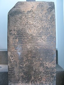
[18] In December 2017, Dr Vong Sotheara, of the Royal University of Phnom Penh, discovered a Pre-Angkorian stone inscription in the Province of Kampong Speu Baset District, which he tentatively dated to 633 CE.
[19] Huntian/Kaundinya I The Book of Liang records a local legend to document Funan's origin, that of the foundation of Funan by the foreigner Hùntián (混塡, Middle Chinese pronunciation /ɦwənx tɦian/): "He came from the southern country Jiào (徼, an unidentified location, perhaps on the Malaysian Peninsula or in the Indonesian archipelago) after dreaming that his personal genie had delivered a divine bow to him and had directed him to embark on a large merchant junk.
Some scholars have identified the conqueror Hùntián of the Book of Liang with the Brahmin Kauṇḍinya who married a nāga (snake) princess named Somā, as set forth in a Sanskrit inscription found at Mỹ Sơn[20]: 37 and dated 658 CE (see below).
[24] The Sanskrit inscription (K.5) of Tháp Mười (known as "Prasat Pram Loven" in Khmer), which is now on display in the Museum of Vietnamese History in Ho Chi Minh City, refers to a Prince Guṇavarman, younger son (nṛpasunu—bālo pi) of a king Ja[yavarman] who was "the moon of the Kauṇḍinya line (... kauṇḍi[n]ya[vaṅ]śaśaśinā ...) and chief "of a realm wrested from the mud".
In this version of the story, Preah Thaong arrives by sea to an island marked by a giant thlok tree, native to Cambodia.
The nāga king drinks the sea around the island and confers the name "Kampuchea Thipdei", which is derived from the Sanskrit (Kambujādhipati) and may be translated into English as "the lord of Cambodia".
[32] Dutch historian J.C. van Leur stressed that it was the local rulers who recognized the benefits of associating with their relatively advanced social technologies and drew from the Indian traditions by encouraging migration of Brahmin clerks to help with the administration.
[34] Successive rulers following Hun-t'ien included Hun-p'an-huang, P'an-p'an, and then Fan Shih-man, "Great King of Funan", who "had large ships built, and sailing all over the immense sea he attacked more than ten kingdoms ... he extended his territory five or six thousand li."
[20]: 65 The Book of Sui (complied in 636) states: "The Kingdom of Zhenla is to the southwest of Linyi and was originally subject to Funan… The surname of its [former] king was that of the Cha-li clan; his given name was Zhiduo-si-na 質多斯那.
Also found was a large canal system that linked the settlements of Angkor Borei and coastal outlets; this suggests a highly organised government.
Many of the mounds show evidence of material culture and landscape modification (inclusive of species-genera biological regimes) ranging from the metal age through the post-Angkorian period and later as evidenced by 13th through 16th century CE Chinese, Thai, Vietnamese, and Cham ceramics.
The evidence suggests a 2000-year or longer period of urbanization, continuous activity, and relatively strong albeit indirect and multi-nodal connections to long-distance value chains.
The urbanization and networking processes demonstrate significant continuity, evolution and longevity before and after the typical first to sixth century CE historic classification scheme.
Kang Tai (康泰) and Zhu Ying (朱應) reported that the Funanese practised slavery and that justice was rendered through trial by ordeal, including such methods as carrying a red-hot iron chain and retrieving gold rings and eggs from boiling water.
The Chinese described the Funanese as people who lived on stilt houses, cultivated rice and sent tributes of gold, silver, ivory and exotic animals.
Archaeological evidence discovered at what may have been the commercial centre of Funan at Óc Eo includes Roman as well as Persian, Indian, and Greek artefacts.
[63] The German classical scholar Albrecht Dihle believed that Funan's main port, was the Kattigara referred to by the 2nd century Alexandrian geographer Ptolemy as the emporium where merchants from the Chinese and Roman empires met to trade.
Dihle also believed that the location of Óc Eo best fit the details given by Ptolemy of a voyage made by a Graeco-Roman merchant named Alexander to Kattigara, situated at the easternmost end of the maritime trade route from the eastern Roman Empire.
[64] Georges Coedès said: "Fu-nan occupied a key position with regard to the maritime trade routes, and was inevitably a port of call both for the navigators who went through the Straits of Malacca and for those – probably more numerous – who made the transit over one of the isthmuses of the Malay Peninsula.
Fu-nan may even have been the terminus of voyages from the Eastern Mediterranean, if it is the case that the Kattigara mentioned by Ptolemy was situated on the western coast of Indochina on the Gulf of Siam".
[68] It is perhaps no small coincidence that the first Roman embassy from "Daqin" recorded in Chinese history is dated 166 AD, allegedly sent by a Roman ruler named "Andun" (Chinese: 安敦; corresponding with the names Antoninus Pius or Marcus Aurelius Antoninus) and arriving through the Eastern Han Empire's southernmost frontier province of Jiaozhi in northern Vietnam.
The Funanese population was concentrated mainly along the rivers of the Mekong Delta; the area was a natural region for the development of an economy based on fishing and rice cultivation.
[54] Contact with Southeast Asia began after the Southward expansion of the Han dynasty, and the annexation of Nanyue and other kingdoms situated in southern China.
[72] A brief conflict is recorded to have happened in the 270s, when Funan and its neighbour, Linyi, joined forces to attack the area of Tongking (Vietnamese: Đông Kinh, "eastern capital"), located in what is now modern Northern Vietnam (which was a Chinese colony at the time).