Latitude (symbol b) measures the angle of an object northward of the galactic equator (or midplane) as viewed from Earth.
[1] In the equatorial coordinate system, for equinox and equator of 1950.0, the north galactic pole is defined at right ascension 12h 49m, declination +27.4°, in the constellation Coma Berenices, with a probable error of ±0.1°.
[2] Longitude 0° is the great semicircle that originates from this point along the line in position angle 123° with respect to the equatorial pole.
[3] Based on this definition, the galactic poles and equator can be found from spherical trigonometry and can be precessed to other epochs; see the table.
Due to the Sun's position, which currently lies 56.75±6.20 ly north of the midplane, and the heliocentric definition adopted by the IAU, the galactic coordinates of Sgr A* are latitude +0° 07′ 12″ south, longitude 0° 04′ 06″.
In some work regarding the distant past or future the galactic coordinate system is taken as rotating so that the x-axis always goes to the centre of the galaxy.
Artist's depiction of the Milky Way Galaxy showing the origin and orientation of galactic longitude. The galactic longitude (
l
) runs from the Sun upwards in the image through the center of the galaxy. The galactic latitude (
b
) is perpendicular to the image (i.e. coming out of the image) and also centered on the Sun.
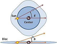
The galactic coordinates use the
Sun
as the origin. Galactic longitude (
l
) is measured with primary direction from the Sun to the center of the galaxy in the galactic plane, while the galactic latitude (
b
) measures the
angle
of the object above the
galactic plane
.
Approx galactic quadrants (NGQ/SGQ, 1–4) indicated, along with differentiating Galactic Plane (containing galactic centre) and the Galactic Coordinates Plane (containing our sun / solar system)
The
anisotropy
of the star density in the night sky makes the galactic coordinate system very useful for coordinating surveys, both those that require high densities of stars at low galactic latitudes, and those that require a low density of stars at high galactic latitudes. For this image the
Mollweide projection
has been applied, typical in maps using galactic coordinates.