Geodetic Observatory Wettzell
These data are used for realizing global coordinate reference systems that form the basis for numerous issues in the field of geosciences (e.g. continental drift, sea level rise), in aerospace, but also in areas of everyday life (e.g. surveying, navigation).
The Geodetic Observatory Wettzell was founded nearby the former Iron Curtain to former Czechoslovakia and to Germany's Air Defense Identification Zone in 1970 in order to have a night sky as dark as possible with only low light pollution and have to take little consideration of air traffic for Satellite and Lunar Laser Ranging.
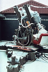
The optical observations carried out until the end of the 1970s included images of satellite passages with the Zeiss Double Astrograph and the ballistic measuring camera Zeiss BMK 75 for satellite triangulation and observations with a circumzenithal and the Danjon Astrolab for astronomical longitude and latitude determination.
The first measurements to the satellite navigation system NAVSTAR GPS were already performed during the test phase 1979–1981 with Wettzell as one of four tracking stations worldwide.
Since 2012, the observatory has two further so-called twin telescopes, in order to take account of technical progress and the increasing observation tasks.