Geography of Guam
The north of Guam is a result of this base being covered with layers of coral reef, turning into limestone, and then being thrust by tectonic activity to create a plateau.
The majority of the population lives on the coralline limestone plateaus of the north, with political and economic activity centered in the central and northern regions.
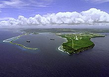
The western coast is leeward of the trade winds and is the location of Apra Harbor, the capitol Hagåtña, and the tourist center of Tumon.
The subduction area is marked by the Mariana Trench, the deepest gash in the earth's surface, which includes three deep spots to the south of Guam.
[4]: 7 The last volcanic layer, called the Umatac formation, was formed by the third and final eruption, which surrounded this ridge in the south of Guam.
[8] Guam's size and possession of a natural safe anchorage at Apra Harbor, uniquely among its neighbors, have driven much of its history.
Located on the east-to-west trade winds, galleons from Mexico would briefly reprovision on Guam before continuing on to Manila.
These relocated people were forced to travel to work on distant farms and ranches, creating the lanchu system of farmsteading, which was to become a traditional part of Chamoru society well into the twentieth century.
The population of Guam and the entire Northern Marianas, except for Rota, was moved to Hagåtña, and five southern villages: Agat, Inarajan, Merizo, Pago (which no longer exists), and Umatac.
The American Naval government build roads and schools in outlying areas in order to urge the population to spend time on their ranch lands and produce more agricultural products.
There were eight municipalities approved by the Naval governor in the 1920s, Hagåtña, Agat, Asan, Inarajan, Merizo, Piti, Sumay and Yona.
[15] The devastation from the U.S. retaking of Guam in 1941 and subsequent military build-up of installations at the end of the Pacific War transformed the island's settlements.
[17] Guam has a tropical marine climate that is generally warm and humid, but moderated by northeast trade winds.
Typhoon Pongsona in 2002 had wind gusts up to 290 km/h (183 mph 1-min) over Guam and caused widespread devastation, but no direct deaths because of strict building standards.
The island also supports feral populations of introduced Philippine deer (Rusa marianna), pigs (Sus scrofa), and carabao (Bubalus bubalis carabanesis).
Tourism from Japan in particular, but increasingly from China and South Korea, largely derives from an attractive tropical climate and amenities.
Mount Lamlam is sometimes claimed to be the world's highest mountain at 37,820 feet (11,530 m), measured from a base in Challenger Deep 304 km (189 mi) away.
[18][19] Even if measured from Sirena Deep, 145 kilometers (90 mi) away, Mount Lamlam is taller than Mauna Kea, which is typically cited as the tallest mountain including subsurface rise from the ocean floor at 10,203 m (33,474 ft).
However, Cocos Island, located off the southern coast of Guam's mainland is the ultimate southernmost point of the territory.