Geography of Mesoamerica
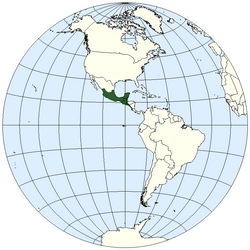
Situated within the wider region known as Middle America,[1] Mesoamerica extends from south-central Mexico southeastward to include the Isthmus of Tehuantepec, the Yucatán Peninsula, Guatemala, Belize, El Salvador, and the Pacific coast of Honduras, Nicaragua, and Costa Rica down to the Gulf of Nicoya.
The term Mesoamerica may occasionally refer to the contemporary region comprising the nine southeastern states of Mexico (Campeche, Chiapas, Guerrero, Oaxaca, Puebla, Quintana Roo, Tabasco, Veracruz, and Yucatán) and the countries of Central America (including Panama).
In the low-lying regions, sub-tropical and tropical climates are most common, as is true for most of the coastline along the Gulf of Mexico and the Caribbean Sea.
The tall mountainous peaks of the Sierra Madres, however, impedes the movement of clouds and reduces the amount of rainfall the region receives.
[citation needed] More recent research has made it clear that the climate past was not very different from that of today, even though the ecosystems do show a significant degree of decline due to human activity.
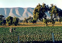
[citation needed] The highlands of Mesoamerica, while not extraordinarily rich, Were sufficiently fertile to allow the development of the high agricultural cultures of ancient, pre-Hispanic times.
[citation needed] In fact, the situation was quite similar to that of other regions of the world where early civilizations thrived, as in the north of Peru, or in the valley of the Indus River in Asia.
The sub-areas generally correlate with known cultural groups, such as the areas where the Maya, Huastec, and Olmec were found, for example.
This area is composed of moderate to cold valleys in the southern part of the Mexican high plateau and in the north of the Balsas River basin.
The valley of Tehuacá, located in the southeast of this region, is important for the early evidence of maize cultivation and some of the oldest ceramic artifacts (sherds) in Mesoamerica.
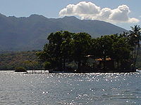
The Valley of Mexico, location of Lake Texcoco, was the home for several important cultures, including Cuicuilco, Teotihuacan, Tula (Toltec), and the Aztec capital of Tenochtitlan.
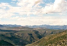
As such, it encompasses a vast and varied landscape, from the mountainous regions of the Sierra Madre to the semi-arid plains of northern Yucatán.
Climate in the Maya region can vary tremendously, as the low-lying areas are particularly susceptible to the hurricanes and tropical storms that frequent the Caribbean.
Geologically, the Maya region consists of a limestone plateau that rises slightly toward the south, ending where the mountainous zone interrupts the plain.
The northwestern part of the peninsula is considered semi-arid and one of the driest in the Maya region, while the northeast receives a greater amount of rainfall.
With the exception of the Puuc hills, which range from central and southern Yucatán into the northern parts of Campeche, there is little topographic variation in the lowlands.
The Sierra Madre mountains are volcanic, and Tajumulco Volcano, at an elevation of 4,220 m (13,845 ft), is the highest point in Central America.
This culture was developed by the chiefdoms that controlled the arable land (which was very fertile, albeit dry) of the small valleys of Etla, Tlacolula, and Miahuatlán.
However, the city of Monte Albán was abandoned in the 10th century CE, and gave way to a series of regional centers that fought among each other for political dominance.
There is little running surface water, and presently, a good part of the area has become alarmingly deforested, a result of the ground-clearing agricultural practices of the ancient inhabitants of the region.
This region was of pivotal importance in the preclassic, as the southern portion acted as the "heartland" of the Olmec civilization as well as the following Epi-Olmec culture.
Through these two cultures, the region witnessed the development of some of the earliest urban centers, written language, calendars and state formation in Mesoamerica.
Central Guerrero corresponds to the Sierra Madre del Sur, a region rich in mineral deposits but poor in agricultural potential.
Lastly, the southern part of the region consists of the Pacific coast, a wide coastal plain, full of mangroves and palms, battered by hurricanes from the south.
The land is suited to cultivation due to its fertility and abundant water resources, especially in the coastal plain of Sinaloa, the Bajío, and the Tarascan Plateau.
When agriculture and the social system collapsed in the North, the occupants of the region migrated towards the West, the Gulf, and the Center of Mexico.
The area known as Centroamerica occupies the Pacific coasts of El Salvador, Honduras, Nicaragua, and the Nicoya Peninsula in Costa Rica.