Geography of Venezuela
Venezuela is a country in South America, bordering the Caribbean Sea and the North Atlantic Ocean, between Colombia and Guyana.
[2][1] It is bound on the north by the Caribbean Sea and the Atlantic Ocean, on the east by Guyana, on the south by Brazil, and on the west by Colombia.
Most observers describe Venezuela in terms of four fairly well-defined regions: the Maracaibo lowlands in the northwest, the northern mountains extending in a broad east–west arc from the Colombian border along the Caribbean Sea, the wide Orinoco plains (Llanos) in central Venezuela, and rank highly dissected Guiana highlands in the southeast.
[2] The Maracaibo lowlands form a large spoon-shaped oval bounded by mountains on three sides and open to the Caribbean on the north.
[2] Broken by several gaps, these high mountains have peaks over 4,500 metres (14,800 ft); the fertile valleys between the ranges contain most of Venezuela's population, industry, and agriculture.
[2] The ranges southeast of Lake Maracaibo contain some of the highest peaks in the country (Pico Bolivar reaches 4,978 m (16,332 ft)), a few of which are snowcapped year-round.
[2][1] A broad gap separates this mountainous area from another rugged pair of ranges that parallel the north-central coast.
[2] Another broad gap separates this area from the easternmost group of mountains, a series of dissected hills and uplands that rise steeply from the Caribbean and extend eastward almost to Trinidad.
[2] North of the Rio Apure, rivers flowing out of the northern mountains cut shallow valleys, leaving eroded ridges that give the land a gently rolling appearance.
[2] Making up over half of the country, the highlands consist primarily of plateau areas scored by swiftly running tributaries of the Orinoco.
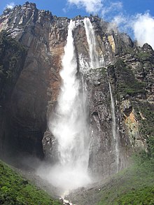
[2] The most conspicuous topographical feature of the region is the Gran Sabana, a large, deeply eroded high plateau that rises from surrounding areas in abrupt cliffs up to 800 metres (2,600 ft).
[2] The temperate zone ranges between 800 and 2,000 m (2,600 and 6,600 ft) with averages from 12 to 25 °C (54 to 77 °F); many of Venezuela's cities, including the capital, lie in this region.
[2] Pastureland and permanent snowfield with yearly averages below 8 °C (46 °F) cover land above 3,000 m (9,800 ft) in the high mountain areas known as the páramos.
[29] A recent example is the discovery of a potential new dinosaur found in the Táchira State, unearthed near the outskirts of the Andes mountains.
[31] The dinosaur was named Tachiraptor admirabilis and is a small specimen measuring in at roughly 1.5 meters from the tip of its tail to the end of its nose.
[31] The team who discovered the dinosaur believe the specimen dates to the 201 million years ago, right at the end of the Triassic and start of the Jurassic period.
[2] The other major Venezuelan river is the fast-flowing Caroní, which originates in the Guiana highlands and flows northward into the Orinoco upstream from Ciudad Guyana.
Electricity generated by the Caroní was one of the factors encouraging industrialization of the northern part of the Guiana highlands and the lower Orinoco valley.
[2] The lake is shallow, with an average depth of ten meters, and separated from the Caribbean by a series of islands and sandbars.
Rivers, like the Rio Orinoco and the Caroní, are susceptible to flooding due in part to the heavy precipitation and intense wet seasons.
[33] Due to this issue of oversaturated soils Venezuela has invested in drainage technology, namely in two large watersheds.
[33] "Frank Radcliffe; a Story of Travel and Adventure in the Forests of Venezuela" was written by a Christian man named Achilles Daunt.
[37] This is a great primary resource that lets historians observe, through intense descriptions, Venezuela prior to industrialization.