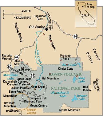
Geology of the Lassen volcanic area
Heat and molten rock from these subducting plates has fed scores of volcanoes in California, Oregon, Washington and British Columbia over at least the past 30 million years, including these in the Lassen volcanic areas.
About 600,000 years ago, Mount Tehama started to rise as a stratovolcano in the southwestern corner of the park, eventually reaching an estimated 11,000 ft (3,400 m) in height.
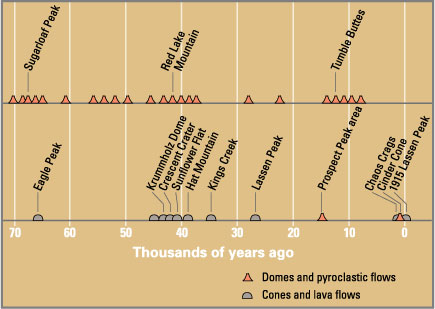
Roughly 27,000 years ago, a dacite lava dome quickly pushed its way through Tehama's former north-eastern flank, becoming the approximately 1,000 ft (300 m) shorter Lassen Peak.
Phreatic (steam explosion) eruptions, dacite and andesite lava flows along with cinder cone formation have persisted into modern times.
The only activity since then has been the constant bubbling of mud pots and steaming of fumaroles from the various geothermal areas in Lassen Volcanic National Park.
Lying some 300 mi (480 km) offshore, the spreading center of the Gorda Plate pushes out about 1 in (2.54 cm) of new crust toward the coast of northernmost California and southern Oregon every year.
Prolonged basaltic volcanism at a single site can produce a sizeable edifice, like the broad, relatively flat shield volcanoes of Prospect Peak and Sifford Mountain.
Just south of the park begins the Sierra Nevada mountain range, and to the east lie the Modoc Plateau and then the Great Basin.
This same bending and breaking of rocks relieved pressure on the hot material beneath the Earth's crust and permitted magma to rise toward the surface.
Volcanoes burst into activity starting 30 million years ago from Washington southward along the Cascades and in the area now occupied by the Sierra Nevada.
From innumerable cracks, floods of highly fluid basaltic lava spread to cover an area of over 200,000 sq mi (520,000 km2).
[1] The High Cascades took shape as a distinct mountain belt as a result of this upheaval and the bending of the thick blanket of volcanic rocks.
A series of volcanic mudflows (lahars) from three major source areas contributed debris that covered almost 2,000 sq mi (5,200 km2) to form the oldest distinctive geologic formation in the High Cascades.
[15] One major source of the formation was Mount Yana; centered a few miles (5 km) southwest of Butt Mountain and south of the park.
[11] Somewhat later, andesitic lavas poured out from what is now Reading Peak and mainly flowed to the south and east, reaching the head of Warner Valley.
Around 610,000 years ago over 130 km3[19] of rhyolite magma violently erupted onto the surface, producing massive pyroclastic flows and an ash plume several tens of kilometers high.
[17] Tehama eventually reached an elevation of about 11,000 ft (3,400 m),[16] was 11 to 15 miles (18 to 24 km) wide at its base,[23] and contained 80 km3 (19 cu mi) of material.
[25] Four shield volcanoes (Raker and Prospect Peaks, Red Mountain and Mount Harkness) grew to elevations of between 7,000 to 8,400 ft (2,100 to 2,600 m) at the corners of the central plateau.
[15] Radiometric dating indicates that around 31,000 years ago a new vent opened up on the northeastern slope of Tehama, probably close to where Lassen Peak now stands.
[27] Lassen grew past the normal maximum size of plug dome volcanoes, 1,000 ft (300 m), and reached a height of 1,800 feet (550 m) above the surrounding plateau[27] in as little as a few years.
[23] When Lassen Peak formed, it looked much like the nearby Chaos Crags domes do today, with steep sides covered by angular rock talus.
[4] In turn the growth of Lassen Peak intercepted moisture, allowing a glacier on its northern flank to grow to almost 10 kilometers (6.2 mi) long.
[31] Other dacite domes which rose on Tehama's flanks are Bumpass Mountain, Helen Ridge, Eagle Peak and Vulcan's Castle.
[1] The crest of Saddle Mountain served as a divide with ice north of it moving into the depression containing Snag and Butte Lakes, while those to the south entered Warner Valley.
At least 300 years ago a series of large avalanches, possibly triggered by steam explosions, occurred on the north side of the Crags.
[34] Around the mid-18th century a series of eruptions produced Cinder Cone in the northeast corner of the park, mantling an area of 30 sq mi (78 km2) with ejecta in the process.
[4] Dacite eruptions in the Lassen area typically begin with steam explosions caused by the interaction of rising magma with ground water.
[4] When dacite magma charged with volcanic gases reaches the surface, it erupts explosively, usually as a vertical column of gas and ash that can rise several miles into the atmosphere.
Heavy fallback of hot ash and rock fragments from eruption columns may generate highly mobile pyroclastic flows that can rush several miles down a volcano's slopes and adjacent valleys.
[4] During periods of extreme rainfall or snow melt, mudflows are sometimes generated by mobilization of loose volcanic debris and soil on the slopes of volcanoes.


