Great Basin
The Great Basin (Spanish: Gran Cuenca) is the largest area of contiguous endorheic watersheds, those with no outlets to the ocean, in North America.
It is noted for both its arid climate and the basin and range topography that varies from the North American low point at Badwater Basin in Death Valley to the highest point of the contiguous United States, less than 100 miles (160 km) away at the summit of Mount Whitney.
The term "Great Basin" is applied to hydrographic,[3][4]: 11 biological,[3] floristic,[4]: 21 physiographic,[4]: 14 topographic,[3] and ethnographic geographic areas.
[4]: 34 The name was originally coined by John C. Frémont, who, based on information gleaned from Joseph R. Walker as well as his own travels, recognized the hydrographic nature of the landform as "having no connection to the ocean".
As observed by Fremont, creeks, streams, or rivers find no outlet to either the Gulf of Mexico or the Pacific Ocean.
The region is bounded by the Wasatch Mountains to the east, the Sierra Nevada and Cascade Ranges to the west, and the Snake River Basin to the north.
The hydrographic Great Basin contains multiple deserts and ecoregions, each with its own distinctive set of flora and fauna.
As it dried during the Holocene epoch, some species retreated to the higher isolated mountains and have high genetic diversity.
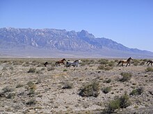
Great Basin wildlife includes pronghorn, mule deer, mountain lion, and lagomorphs such as black-tailed jackrabbit and desert cottontail and the coyotes that prey on them.
Exotic species, including chukar, grey partridge, and Himalayan snowcock, have been successfully introduced to the Great Basin, although the latter has only thrived in the Ruby Mountains.
[20] The basin and range topography is the result of extension and thinning of the lithosphere, which is composed of crust and upper mantle.
To the north are; in California Susanville, in Oregon Burns and Hines, in Idaho Malad and in Wyoming Evanston.
To the south are Cedar City, Tonopah, and Bishop and the very southern area of the basin has the communities of Pahrump, Palmdale, Victorville, and Palm Springs.
[29] Archaeological evidence of habitation sites along the shore of Lake Lahontan date from the end of the ice age when its shoreline was approximately 500 feet (150 m) higher along the sides of the surrounding mountains.
[30] The next group to live in the area was the Great Basin Desert Archaic, from approximately 9,000 to 1,500 years ago.
They hunted animals like mule deer and antelope and gathered onions, wild rye, and pinyon pine nuts.
Unlike the Paleo-Indians, who moved around to follow bison herds, the Fremont built small villages and grew crops like corn and squash.
[citation needed] European exploration of the Great Basin occurred during the 18th century Spanish colonization of the Americas.
The first immigrant American to cross the Great Basin from the Sierra Nevada was Jedediah Strong Smith in 1827.
[31] Peter Skene Ogden of the British Hudson's Bay Company explored the Great Salt Lake and Humboldt River regions in the late 1820s, following the eastern side of the Sierra Nevada to the Gulf of California.
[33] Around 1902, the San Pedro, Los Angeles and Salt Lake Railroad was constructed in the lower basin and Mojave Desert for California-Nevada rail service to Las Vegas, Nevada.
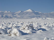
Due to the region's altitude and aridity, most areas in the Great Basin experience a substantial diurnal temperature variation.