Great Lakes Storm of 1913
The storm impacted many cities, including Duluth, Minnesota; Chicago, Illinois; and Cleveland, Ohio, which received 22 in (56 cm) of snow combined with winds up to 79 mph (127 km/h) and was paralyzed for days.
The extratropical cyclone originated when two major storm fronts fueled by the Great Lakes' relatively warm waters—a seasonal process called a "November gale"—converged.
[4] The contemporaneous weather forecasters did not have enough data, communications, analysis capability and understanding of atmospheric dynamics to predict the storm.
The water in the five Great Lakes holds heat that allows them to remain relatively warm late into the year and postpones the cooling and first frosts in the region.
The collision of these air masses forms large storm systems in the middle of the North American continent, including the Great Lakes.
During a November gale in 1975, the giant bulk carrier SS Edmund Fitzgerald sank suddenly without sending a distress signal and with all crew still on board.
[9] Compared to the ocean, the Great Lakes also have less maneuvering "sea room" and closer proximity to shores, making it more difficult for ships to weather storms.
[13] Around midnight on November 6–7, the steamer Cornell, which was 50 miles (80 km) west of Whitefish Point in Lake Superior, ran into a sudden northerly gale and was severely damaged.
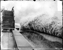
[1] The northwest portion of this extremely powerful storm began creating strong winds from the north along the long axis of Lake Huron, building large waves.
By November 10, twenty-four hours of such building had created immense waves which ships were subjected to along with the high winds as the center of the storm crossed north/northwest over Lake Erie near Toronto.
[17] At 10:00 a.m., United States Coast Guard stations and all 112 Weather Bureau signal stations on the Great Lakes received a directive to hoist a square, red signal flag with a black center and a red, triangular maritime pennant below it, indicating a storm with winds of 55 mph (89 km/h) that would blow from the southwest.
[24] The 472-foot steel bulk freighter L. C. Waldo, eighteen hours out of Two Harbors, Minnesota, was overrun by monster waves out of the northwest on Lake Michigan.
As recounted by second mate Feeger: "The wind sent on gigantic wave after another over parts of the ship...The snow was so blinding that none of us could see 50 feet ahead".
[11] L. C. Waldo's rudder then failed; helpless without it, 70mph winds drove the ship aground on Gull Rock near Manitou Island.
[25] The steward's wife and her mother were reluctant to leave the stern and the crew struggled to carry them over hundreds of feet of open deck in the storm, including traversing a now-widening crack.
This proved to be a serious problem; the storm would have most of the day to build up hurricane-force winds before the Bureau headquarters in Washington would have detailed information.
In Buffalo, New York, morning northwest winds had shifted to the northeast by noon and to the southeast by 5:00 p.m., with gusts of up to 80 mph (130 km/h) occurring between 1:00 p.m. and 2:00 p.m.
In Cleveland, Ohio, 180 miles (290 km) to the southwest, winds remained northwest during the day, shifting to the west by 5:00 p.m., and maintaining speeds of more than 50 mph (80 km/h).
[30] Weather forecasters of the time did not have enough data or understanding of atmospheric dynamics to predict or comprehend the events of Sunday November 9.
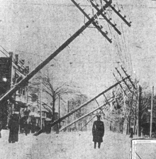
Streetcar operators stayed with their stranded, powerless vehicles for two nights, eating food provided by local residents.
[42] Immediately following the blizzard, the city began a campaign to move all utility cables underground in tubes beneath major streets.
In the late afternoon of November 10, an unknown vessel was spotted floating upside-down in about 60 feet (18 m) of water on the eastern coast of Michigan, within sight of Huronia Beach and the mouth of the St. Clair River.
"[45] Milton Smith, an assistant engineer who decided at the last moment not to join his crew on premonition of disaster, helped identify bodies from the wreck.
[49] The Weather Bureau did not have the ability to predict the storm but hesitated to admit its limitations because it wanted to secure higher budgets.
[50] Another factor was the underpowering of large ships that affected their ability to travel, maneuver and hold steady in severe storms.
Even with both anchors dropped and steaming full power into the wind, several were unable to avoid being carried backward.
[51] The geometry of the lakes and locks, combined with operational economics, dictated the use of slimmer, shallower ships than comparable ocean-going vessels, reducing stability and structural strength.
[52] The "straight deck" ship design was becoming prevalent, requiring more and larger hatch covers, which increased vulnerability to storms.
[55] The practice of not "trimming" or leveling the pyramid-shape piles of bulk solid cargo made them more prone to shifting and causing a capsize.
[59] One change was that the Weather Bureau clarified their previous ambiguity and said that they would post a higher-than-gale level warning for the most severe predicted storms.