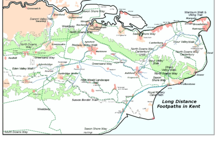
Greensand Way
The Greensand Way is a long-distance path of 108 miles (174 km) in southeast England, from Haslemere in Surrey to Hamstreet in Kent.
The trail was opened on 15 June 1980 and is jointly managed by Surrey and Kent Councils who fully updated it in 2012 (route, waymarking, online guide).
[4] An updated guide with maps and walk directions is available online from the Kent and Surrey Council websites.
[5] On Ordnance Survey Explorer map 145, a spur – also labelled Greensand Way – is shown from Thursley to Farnham; this is not part of the path.
Places passed along the trail include: Hindhead, Thursley, Wormley, Hambledon, Hascombe, Shamley Green, Holmbury St Mary, Wotton, Westcott, Dorking, Brockham, Betchworth, Reigate, Earlswood, South Nutfield, Bletchingley, Godstone, Tandridge, Broadham Green, Limpsfield, Crockham Hill, Toys Hill, Ide Hill, Sevenoaks Weald, Knole Park, Shipbourne, Dunk's Green, West Peckham, Nettlestead Green, Yalding, Linton, Sutton Valence, Egerton, Pluckley, Little Chart, Hothfield, Kingsnorth and finally Hamstreet.