Outflow boundary
An outflow boundary, also known as a gust front, is a storm-scale or mesoscale boundary separating thunderstorm-cooled air (outflow) from the surrounding air; similar in effect to a cold front, with passage marked by a wind shift and usually a drop in temperature and a related pressure jump.
Outflow boundaries can persist for 24 hours or more after the thunderstorms that generated them dissipate, and can travel hundreds of kilometers from their area of origin.
Strong versions of these features known as downbursts can be generated in environments of vertical wind shear and mid-level dry air.
[3] Outflow boundaries can persist for over 24 hours and travel hundreds of kilometers (miles) from their area of origin.
[6] Organized areas of thunderstorm activity reinforce pre-existing frontal zones, and can outrun cold fronts.
When the convection is strong and linear or curved, the MCS is called a squall line, with the feature placed at the leading edge of the significant wind shift and pressure rise which is normally just ahead of its radar signature.
An expansion of the rain shaft near ground level, in the general shape of a human foot, is a telltale sign of a downburst.
[14] As such, fine line patterns within weather radar imagery, associated with converging winds, are dominated by insect returns.
If squall lines form over arid regions, a duststorm known as a haboob can result from the high winds picking up dust in their wake from the desert floor.
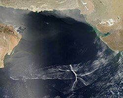
[16] If outflow boundaries move into areas of the atmosphere which are stable in the low levels, such through the cold sector of extratropical cyclones or a nocturnal boundary layer, they can create a phenomenon known as an undular bore, which shows up on satellite and radar imagery as a series of transverse waves in the cloud field oriented perpendicular to the low-level winds.