Haidao Suanjing
[1] During the Tang dynasty, this appendix was taken out from The Nine Chapters on the Mathematical Art as a separate book, titled Haidao suanjing (Sea Island Mathematical Manual), named after problem No 1 "Looking at a sea island."
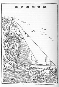
This work provided detailed instructions on how to measure distances and heights with tall surveyor's poles and horizontal bars fixed at right angles to them.
The units of measurement were Calculation was carried out with place value decimal Rod calculus.
Liu Hui used his rectangle in right angle triangle theorem as the mathematical basis for survey.
With eye on ground level, the tip of the pole is on a straight line with the peak of island.
Then view the tree trunk, the line of sight intersects the poles at 2 chi and 8 cun from its tip .
Answer: the height of the pine is 12 zhang 2 chi 8 cun, the distance of mountain from the pole is 1 li and (28 + 4/7) steps.
Set up an east gnome and a west pole, 6 zhang apart, linked with a rope at eye level.
Move back 5 steps from the north gnome, watch the NW corner of the city, the line of sight intersects the rope at 2 zhang 2 chi and 6.5 cun from the east end.
The 19th century British Protestant Christian missionary Alexander Wylie in his article "Jottings on the Sciences of Chinese Mathematics" published in North China Herald 1852, was the first person to introduce Sea Island Mathematical Manual to the West.
[1] In 1986 Ang Tian Se and Frank Swetz translated Haidao into English.
After comparing the development of surveying in China and the West, Frank Swetz concluded that "in the endeavours of mathematical surveying, China's accomplishments exceeded those realized in the West by about one thousand years.