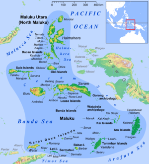
Halmahera Sea
It covers about 95,000 km (59,000 mi) and its topography comprises a number of separate basins and ridges, the chief of which is the Halmahera Basin reaching a depth of 2039 m. The International Hydrographic Organization (IHO) defines the Halmahera Sea as being one of the waters of the East Indian Archipelago.
The IHO defines its limits as follows:[1] On the North A line from Wajaboela (Morotai) to Tg.
The Northern limit of Ceram Sea between Obi Major and New Guinea [A line from ... Obi Major ... Tanjong Seranmaloleo its Eastern extreme, thence through Tobalai, Kekek, Pisang and Kofiau Islands to Tanjong Sele (1°26′S 130°55′E / 1.433°S 130.917°E / -1.433; 130.917), the Western point of New Guinea].
The Southern limit of Molukka Sea [sic] between Halmahera and Obi Major [A line from the Southern extreme of Halmahera to the North point of Bisa (Setile) Island, thence to the Northern extreme of Obi Major].
You can help Wikipedia by expanding it.This North Maluku location article is a stub.