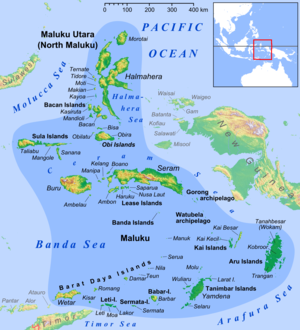
Seram Sea
It is a section of the Pacific Ocean with an area of approximately 120,000 km2 (46,000 sq mi) located between Buru and Seram, which are two of the islands once called the South Moluccas.
These islands are the native habitat of plants long coveted for their use as spices, such as nutmeg, cloves, and black peppercorns, and the seas surrounding them were busy shipping routes.
The International Hydrographic Organization (IHO) defines the Seram Sea as being one of the waters of the East Indian Archipelago.
From the Northern point of pulau Nuhuyut (Groot Kai) through the Watubela and Gorong Islands to the Southeastern extreme of Ceram, along its Northern shore to Tanjung Tandurubesar , the Northwest point, thence a line to Tanjung Baturuhan, the Northern extreme of Buru [Buru], and along the coast to Tanjung Palpetu, the Northwest point of the Island.
A line from Tanjung Palpetu to Tanjung Waka, the Southern point of pulau Sanana, through this island to its Northern point, thence across the Mangoli Strait to the South coast of Mangole (Sula Islands) in [1°56′S 125°55′E / 1.933°S 125.917°E / -1.933; 125.917].