Sea of Japan
Its water balance is mostly determined by the inflow and outflow through the straits connecting it to the neighboring seas and the Pacific Ocean.
The intensity of shipments across the sea has been moderate owing to political issues, but it is steadily increasing as a result of the growth of East Asian economies.
In 1796, a British naval officer, William Robert Broughton, explored the Strait of Tartary, the eastern coast of the Russian Far East and the Korean Peninsula.
In 1803–1806, the Russian navigator Adam Johann von Krusenstern while sailing across the globe in the ship Nadezhda also explored, in passing, the Sea of Japan and the eastern shores of Japanese islands.
[27] In the Early Miocene the Japan Sea started to open, and the northern and southern parts of the Japanese archipelago separated from each other.
[27] The orogenesis of high mountain ranges in north-eastern Japan started in Late Miocene and lasted in Pliocene also.
Their formation had interrupted the migration of elephants into the Japanese islands at the end of the Neogene Period (about 2.6 million years ago).
The most recent is La Perouse Strait, which formed about 60,000 to 11,000 years ago closing the path used by mammoths which had earlier moved to northern Hokkaidō.
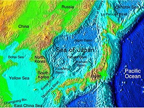
It has a carrot-like shape, with the major axis extending from south-west to north-east and a wide southern part narrowing toward the north.
In addition, an underwater ridge rising up to 3,500 m (11,500 ft) runs from north to south through the middle of the central part.
Seabed down to 300 m (980 ft) is of continental nature and is covered with a mixture of mud, sand, gravel and fragments of rock.
The most significant islands are Moneron, Rebun, Rishiri, Okushiri, Ōshima, Sado, Okinoshima, Ulleungdo, Askold, Russky and Putyatin.
The shorelines are relatively straight and lack large bays and capes; the coastal shapes are simplest in Sakhalin and are more winding in the Japanese islands.
Prominent capes include Lazareva, Peschanyi (sandy), Povorotny, Gromova, Pogibi, Tyk, and Korsakova in Russia; Crillon on Sakhalin; Sōya, Nosappu, Tappi, Nyuda, Rebun, Rishiri, Okushiri, Daso and Oki in Japan;[29][13] and Musu Dan in North Korea.
There is controversy as to whether or not in each ice cap advance the world sea level fell low enough for the deepest, the western channel of the Korea Strait, to dry and close, turning the Sea of Japan into a huge cold inland lake with a surface layer of fresh water, freezing over in the winters.
This winter monsoon brings typhoons and storms, with the waves reaching 8–10 m (26–33 ft) which erode the western coasts of Japan.
[29] In summer the wind weakens to 2–7 m/s (6.6–23.0 ft/s) and reverses its direction, blowing warm and humid air from the North Pacific onto the Asian mainland.
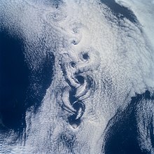
[13] A peculiar turbulent cloud pattern, named von Kármán vortices, is sometimes observed over the Sea of Japan.
The Northeastern limit of the Eastern China Sea [From Nomo Saki (32°35′ N) in Kyusyu to the South point of Hukae Sima (Goto Retto) and on through this island to Ose Saki (Cape Goto) and to Hunan Kan, the South point of Saisyu To (Quelpart), through this island to its Western extreme and thence along the parallel of 33°17′ North to the mainland] and the Western limit of the Inland Sea [defined circuitously as "The Southeastern limit of the Japan Sea"].
The returning branch is composed of the Liman, North Korea and Central (or Mid-) Japan Sea currents which bring fresh and cold water along the Asian coast to the south.
[12][29] The hydrological isolation of the Sea of Japan also results in slightly lower average water salinity (34.09‰, where ‰ means parts per thousand) compared with the Pacific Ocean.
[13] Few rivers flow into the Sea of Japan from mainland Asia, the largest being Tumen,[13] Rudnaya, Samarga, Partizanskaya and Tumnin; all of them have a mountainous character.
The total annual river discharge into the sea is 210 km3 (50 cu mi) and is relatively constant through the year, except for a minor increase in July.
Between October and April, the outflow exceeds the inflow due to the lower income through the Korea Strait; this balance reverses between May and September.
Wind may also locally change the water level by 20–25 cm (8–10 in); for example, it is higher in summer at the Korean and lower at the Japanese coasts.
They are rich in dissolved oxygen, especially in the western and northern parts, which are colder and have more phytoplankton than the eastern and southern areas.
There is a regular ferry service across the Strait of Tartary between the Russian continental port of Vanino and Kholmsk in Sakhalin.
[29] The sea has magnetite sands as well as natural gas and petroleum fields near the northern part of Japan and Sakhalin Island.
The major Russian port of Vladivostok mainly serves inland cargos, whereas Nakhodka and Vostochny are more international and have a busy exchange with Japan and South Korea.
[13] The intensity of shipments across the Sea of Japan is steadily increasing as a result of the growth of East Asian economies.