Herne Hill railway station
The arrival of the railways transformed Herne Hill from a wealthy suburb with large residential estates into a densely populated urban area.
[8] The station entrance canopy (which had been shortened and altered in the mid-20th century) was removed in 2015, owing to its state of disrepair; a new one was installed in July 2016, with a new timber valance design and cornice based on the original Victorian one.
[16] Sanders granted leases for large plots of land to wealthy families – John Ruskin spent his childhood at an estate on Herne Hill.
The Effra was covered over in the 1820s;[14] and the area had become an upper-class suburb by the mid-19th century (a contemporary author referred to the hill as "the Elysium" for merchants).
[17] The opening of the railway station, which provided convenient and cheap access to central London, started the urbanisation of Herne Hill.
It reached an agreement with the London, Brighton and South Coast Railway (LB&SCR) in 1858 to use its West End and Crystal Palace line to access Battersea and (from 1860) Victoria.
This arrangement incurred costly access fees, but it was necessary until the company obtained Parliamentary authority to build in London.
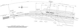
[28] The route from Beckenham Junction to Battersea closely resembled that of the 1852 proposal, going via Clapham, Brixton, Herne Hill, Dulwich and Sydenham.
[18] The building was intended to impress: it had tea rooms offering buffets,[31] decorative brickwork and a tower (which also served the practical function of concealing the water tank for steam locomotives).
It also stated that "an unusual amount of decorative taste has been displayed" in the station's construction; even the viaduct was praised as "one of the most ornamental pieces of work we have ever seen attempted on a railway" for its fine brickwork.
[33] The station's design prompted the journal to write a 2,000-word editorial bemoaning the comparatively poor architectural quality of other contemporary civil engineering projects.
The station's original signal box, elevated above the railway viaduct at the junction between Norwood Road and Half Moon Lane, was a prominent feature in Herne Hill for many years.
[45] Express journeys from Herne Hill to Dover, a distance of 74 mi (119.1 km), took 1 hour 36 minutes, at an average speed of 46.25 mph (74.4 km/h).
[49] The LCDR was compelled to operate this service by Parliament to compensate for the large number of working-class homes destroyed in Camberwell during the construction of the City Branch.
In 1885, the LCDR decided to use Blackfriars Bridge railway station solely as a goods yard but lacked the space to sort wagons at the site.
[64] A stationmaster's house was built at 239 Railton Road in the mid-1880s as the site offered a good view of the station (it is now privately owned).
[71][72] On 12 July 1925, a 660-volt third-rail system came into operation on both routes through Herne Hill, from Victoria to Orpington on the Chatham Main Line and along the entire length of the City Branch.
[75] The replacement signal box was in use from June 1956 until December 1981, when its functions were transferred to Victoria; the building still exists and is used by railway staff.
[76] The signalling at Herne Hill was upgraded from semaphores to colour lights on 8 March 1959 as part of the Kent Coast electrification plan.
Network Rail initially suggested widening the viaduct and demolishing part of the market, but the public backlash against this plan prompted Network Rail to consider permanently routing all Thameslink trains to/from Brighton via Herne Hill, avoiding London Bridge and the market.
[83] This proposal was rejected in 2004 because of its environmental impact on Herne Hill and the larger number of interchanges offered on the London Bridge route; the Borough Market viaduct was widened instead.
[82] From 1994 until the completion of High Speed 1 in November 2007 Eurostar services linking London Waterloo to Brussels and Paris passed through Herne Hill without stopping.
A light engine travelling towards Tulse Hill was waiting to cross the south junction when it was struck from behind by an express passenger train from Victoria that had passed a signal at danger.
[95] A second fatal collision occurred at the sorting sidings, just north of the station, on 1 April 1960 in fog that reduced visibility to 60 ft (18.3 m).
[96] Network Rail has forecast that by 2031 there will be 900 more passengers attempting to travel on the route between Herne Hill and Blackfriars during the busiest peak hour every weekday than can be accommodated on the trains.
[100] Grade-separation was supported by Southeastern[101] and First Capital Connect believed it should be given more consideration,[102] but Network Rail has stated that it would be difficult to carry out the work because the station is on a viaduct and surrounded by buildings.
[104][98] This project would also enable the platforms at Herne Hill to be lengthened to accommodate 12-car trains as the current northern junction, which prevents them from being extended, would be removed.