History of geology
Aristotle developed one of the first evidence-based concepts connected to the geological realm regarding the rate at which the Earth physically changes.
Much later in the Roman period, Pliny the Elder produced a very extensive discussion of many more minerals and metals then widely used for practical ends.
In medieval China, one of the most intriguing naturalists was Shen Kuo (1031–1095), a polymath personality who dabbled in many fields of study in his age.
This was based on his observations of sedimentary uplift, soil erosion, deposition of silt, and marine fossils found in the Taihang Mountains, located hundreds of miles from the Pacific Ocean.
[8][failed verification] To prove the Bible's authenticity, individuals felt the need to demonstrate with scientific evidence that the Great Flood had in fact occurred.
His investigations and his subsequent conclusions on these topics have led scholars to consider him one of the founders of modern stratigraphy and geology[12][13] (Steno, who became a Catholic as an adult, was eventually made a bishop, and was beatified in 1988 by Pope John Paul II.
Moreover, the increasing economic importance of mining in Europe during the mid to late 18th century made the possession of accurate knowledge about ores and their natural distribution vital.
[14] Scholars began to study the makeup of the Earth in a systematic manner, with detailed comparisons and descriptions not only of the land itself, but of the semi-precious metals it contained, which had great commercial value.
Also during the eighteenth century, aspects of the history of the Earth – namely the divergences between the accepted religious concept and factual evidence – once again became a popular topic for discussion in society.
In 1749, the French naturalist Georges-Louis Leclerc, Comte de Buffon published his Histoire Naturelle, in which he attacked the popular Biblical accounts given by Whiston and other ecclesiastical theorists of the history of the Earth.
By the 1770s, chemistry was starting to play a pivotal role in the theoretical foundation of geology and two opposite theories with committed followers emerged.
Those who followed this thesis during the early nineteenth century referred to this view as Plutonism: the formation of the Earth through the gradual solidification of a molten mass at a slow rate by the same processes that had occurred throughout history and continued in the present day.
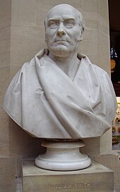
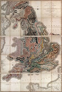
"[23] In England, the mining surveyor William Smith, starting in the 1790s, found empirically that fossils were a highly effective means of distinguishing between otherwise similar formations of the landscape as he travelled the country working on the canal system and produced the first geological map of Britain.
At about the same time, the French comparative anatomist Georges Cuvier assisted by his colleague Alexandre Brogniart at the École des Mines de Paris realized that the relative ages of fossils could be determined from a geological standpoint; in terms of what layer of rock the fossils are located and the distance these layers of rock are from the surface of the Earth.
Through the synthesis of their findings, Brogniart and Cuvier realized that different strata could be identified by fossil contents and thus each stratum could be assigned to a unique position in a sequence.
In early nineteenth-century Britain, catastrophism was adapted with the aim of reconciling geological science with religious traditions of the biblical Great Flood.
In the early 1820s English geologists including William Buckland and Adam Sedgwick interpreted "diluvial" deposits as the outcome of Noah's flood, but by the end of the decade they revised their opinions in favour of local inundations.
[24] In 1831 Captain Robert FitzRoy, given charge of the coastal survey expedition of HMS Beagle, sought a suitable naturalist to examine the land and give geological advice.
This fell to Charles Darwin, who had just completed his BA degree and had accompanied Sedgwick on a two-week Welsh mapping expedition after taking his Spring course on geology.
This idea was confirmed when the Beagle surveyed the Cocos (Keeling) Islands, and in 1842 he published his theory on The Structure and Distribution of Coral Reefs.
Darwin's discovery of giant fossils helped to establish his reputation as a geologist, and his theorising about the causes of their extinction led to his theory of evolution by natural selection published in On the Origin of Species in 1859.
[32] He assumed that the Earth had formed as a completely molten object, and estimated the amount of time it would take for the near-surface to cool to its present temperature.
[33] The discovery of radioactivity in the early twentieth century provided an additional source of heat within the Earth, allowing for an increase in Thomson's calculated age, as well as a means of dating geological events.
In 1911 Arthur Holmes, among the pioneers in the use of radioactive decay as a means of measuring geological time, dated a sample from Ceylon at 1.6 billion years old using lead isotopes.
British geophysicist S. K. Runcorn suggested the concept of paleomagnetism from his finding that the continents had moved relative to the Earth's magnetic poles.
[40] A symposium on continental drift[41] that was held at the Royal Society of London in 1965 must be regarded as the official start of the acceptance of plate tectonics by the scientific community.
[citation needed] In recent years, geology has continued its tradition as the study of the character and origin of the Earth, its surface features and internal structure.
These images can be used to map major geological units, recognize and correlate rock types for vast regions and track the movements of Plate Tectonics.