History of the central steppe
On the east it is separated from Dzungaria and the eastern steppe by the low mountains along the current Chinese border.
In the east the Tian Shan mountains of Kyrgyzstan extend about 650 kilometres west and give the steppe a sharp southern boundary.
The center is approximately the line of the Syr Darya, which runs from the eastern mountains northwest to the Aral Sea.
South of the Syr Darya the steppe grades into semi-desert, but there are cities based on irrigation agriculture which give the area a different history.
The Syr Darya and the area between the Urals and Caspian were not significant barriers, and the low mountains of Dzungaria were fairly easy to cross.
Most of the "peoples" mentioned were some tribe or clan that gained power over its neighbors and became important enough to be noticed by literate historians.
The area north of the Tien Shan needs special treatment because of better documentation and the large number of peoples who moved through it.
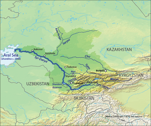
Note the east-west Kyrgyz mountains

Omits Yamnaya culture northwest of the Caspian.