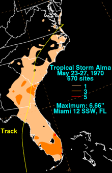
Hurricane Alma (1970)
After progressing northwestward and crossing western Cuba, Alma reorganized in the Gulf of Mexico, although continued shear prevented strengthening.
While it was weakening, Alma produced flooding in central and eastern Cuba, causing seven deaths and forcing 3,000 people to evacuate.
Late on May 17, the US National Hurricane Center, reported that a tropical depression had formed about 470 miles (760 km) to the southeast of Kingston, Jamaica.
That day, it rapidly strengthened under favorable developmental conditions, which included low wind shear, strong upper-level outflow, and apparent eastward inflow.
In January 2022, as part of the ongoing HURDAT Atlantic hurricane reanalysis project, the peak intensity of Alma was downgraded slightly to 75 mph (120 km/h).
[1] By May 22, the low pressure area became poorly defined after stalling south of Cuba; with only a few squalls and showers, advisories were discontinued on Alma.
[4] On May 24, the low pressure area reorganized as spiral rainbands became more evident on radar, and Alma was re-classified as a tropical depression.

Tropical storm (39–73 mph, 63–118 km/h)
Category 1 (74–95 mph, 119–153 km/h)
Category 2 (96–110 mph, 154–177 km/h)
Category 3 (111–129 mph, 178–208 km/h)
Category 4 (130–156 mph, 209–251 km/h)
Category 5 (≥157 mph, ≥252 km/h)
Unknown
