Hurricane Bud (2006)
After reaching cooler waters and an unfavorable environment, the hurricane rapidly weakened and dropped to a tropical depression status on July 15.
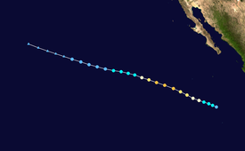
The storm tracked west-northwestward throughout its entire duration, under the steering currents of a mid-level subtropical ridge which extended westward from northern Mexico.
[1] Initially, a small upper-level low pressure system to the north of the depression generated northerly wind shear and dry air, which inhibited the development of thunderstorm activity.
[1] With more favorable conditions, the storm displayed a fairly organized banding pattern, and the previously exposed center of circulation became surrounded by convection.
[1] The convection surrounding the center deepened, and a burst of thunderstorm activity within the southeastern eyewall obscured the eye on satellite imagery.
Outflow was well established in all quadrants, though it was slightly restricted to the east, which was believed to have resulted from interaction with Tropical Storm Carlotta.
The low fully dissipated within the low-level easterly trade winds on July 17, about 750 mi (1,210 km) east-northeast of Hawaii.
Tropical storm (39–73 mph, 63–118 km/h)
Category 1 (74–95 mph, 119–153 km/h)
Category 2 (96–110 mph, 154–177 km/h)
Category 3 (111–129 mph, 178–208 km/h)
Category 4 (130–156 mph, 209–251 km/h)
Category 5 (≥157 mph, ≥252 km/h)
Unknown
