Hurricane Katia (2017)
The storm quickly dissipated several hours later, although its mid-level circulation remained intact and later spawned what would become Hurricane Otis in the Eastern Pacific.
The system subsequently interacted with a mid-level trough over the eastern Gulf of Mexico on September 3,[1] and the National Hurricane Center (NHC) began monitoring it for potential tropical cyclogenesis, despite largely unfavorable environmental conditions.
[3] A well-defined surface circulation formed on September 5, and thus, the system became a tropical depression at 12:00 UTC about 40 mi (65 km) east of the Tamaulipas–Veracruz state line.
[1] The NHC initiated advisories on Tropical Depression Thirteen at 21:00 UTC, after ASCAT data indicated a well-defined circulation and winds of 35 mph (56 km/h).
With gradually decreasing wind shear and warm sea surface temperatures, the system intensified into Tropical Storm Katia on September 6, as the convection became better organized.
[5] An aircraft reconnaissance flight into the storm later on September 6 found a partial eyewall and surface winds of 76 mph (122 km/h); on that basis, the NHC upgraded Katia to hurricane status.
[8] On September 7, a developing ridge over the northern Gulf of Mexico caused Katia to turn west-southwestwards as it continued to slowly strengthen.
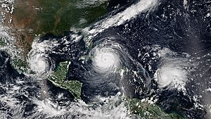
[8] Six hours later, Katia reached peak intensity with maximum sustained winds of 105 mph (165 km/h) and a minimum pressure of 972 mbar (hPa; 28.70 inHg).
[1] Katia's remnants traveled across Central America and later emerged over the Pacific Ocean, where they contributed to the development of Tropical Depression Fifteen-E.
[10] The Servicio Meteorológico Nacional warned residents and tourists not to visit Popocatépetl and Pico de Orizaba due to the possibility of lahars.
[1] The cyclone brought floods, mudslides, and strong winds to areas recently devastated by Mexico's most damaging earthquake in over 100 years.
[17][18] Following the storm, it was requested of the Interior Secretariat to declare a state of emergency in 40 municipalities, granting the authority to use federal funds for disaster relief.

Tropical storm (39–73 mph, 63–118 km/h)
Category 1 (74–95 mph, 119–153 km/h)
Category 2 (96–110 mph, 154–177 km/h)
Category 3 (111–129 mph, 178–208 km/h)
Category 4 (130–156 mph, 209–251 km/h)
Category 5 (≥157 mph, ≥252 km/h)
Unknown