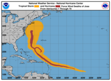
Hurricane Jose (2017)
Initially projected to impact the Antilles already affected by Hurricane Irma, Jose triggered evacuations in catastrophically damaged Barbuda, as well as in Saint Martin.
Later on, Jose brought heavy rain, swells, and rough surf to the East Coast of the United States, causing beach erosion and some flooding.
However, environmental conditions favored gradual development, which prompted the National Hurricane Center (NHC) to start tracking the system.
[4] Once Jose became a tropical storm, gradual intensification ensued within the favorable environment of warm sea surface temperatures, low wind shear, and abundant moisture.
[1] Early on September 6, a period of rapid intensification ensued, due to the favorable conditions, with Jose attaining hurricane intensity by 18:00 UTC that day.
[6] Despite being close to the outflow from the much larger Hurricane Irma to its west, Jose continued to quickly intensify over the next two days, which eventually culminated with it attaining peak winds of 155 mph (250 km/h) and a minimum pressure of 938 mbar (27.7 inHg) at 18:00 UTC on September 8, while located to the east of the Leeward Islands.
[1] Jose slowly weakened as the eye became cloud-filled and wind shear began affecting the storm,[7] dropping below Category 4 intensity by 18:00 UTC on September 10.
[11] Despite an asymmetric appearance on satellite imagery, the hurricane intensified slightly, reaching a secondary peak intensity of 90 mph (150 km/h) at 12:00 UTC on September 17.
[1] The wind field expanded as Jose continued northward, and a large convective band developed along the northern periphery as the central area of thunderstorms diminished.
[16] Early on September 22, the NHC redesignated Jose as a post-tropical cyclone, after convection had diminished for over 12 hours, and since the storm had acquired a frontal system.
[23] Moist southerly flow across the United States Virgin Islands resulted in thunderstorm activity; some flooding occurred on Saint Croix, inflicting $500,000 in damage.
[25] On September 18 and 19, while passing far to the northwest of Bermuda as a Category 1 hurricane, Jose's outer bands produced wind gusts as high as 46 mph (74 km/h) and nearly 2.5 in (64 mm) of rain on the islands.
[28] The NHC issued a tropical storm warning for portions of the Atlantic coastline, including the Outer Banks in North Carolina, through Delmarva and the Jersey Shore.
[15] On September 19, rough surf and swells from Jose flooded portions of the Outer Banks of North Carolina, causing road closures along sections of NC 12.

Tropical storm (39–73 mph, 63–118 km/h)
Category 1 (74–95 mph, 119–153 km/h)
Category 2 (96–110 mph, 154–177 km/h)
Category 3 (111–129 mph, 178–208 km/h)
Category 4 (130–156 mph, 209–251 km/h)
Category 5 (≥157 mph, ≥252 km/h)
Unknown