Hurricane Katrina (1981)
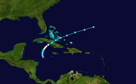
Hurricane Katrina was a late-forming tropical cyclone that impacted portions of the Greater Antilles and Bahamas in November 1981.
On Grand Cayman, a waterspout ripped out a grape tree and slammed it into the Brac Reef Hotel's bar.
The Bahamas received up to 14 in (360 mm) of rain, causing flood damage to watermelon, tomato and corn crops, particularly on Long Island.
The system was designated a tropical depression early on November 3, while located about 150 miles (240 km) to the south of the Cayman Islands.
[1] Operationally, the National Hurricane Center began issuing advisories on the tropical depression at 2200 UTC on November 3.
In the initial advisory, it was noted that the depression would slowly strengthen, but reach tropical storm status within 24 hours due to "strong" convection.
[2] The depression remained disorganized through early on November 4, with satellite imagery and weather stations in the Caribbean Sea region indicating no intensification.
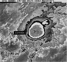
[4] Later that same day, Katrina attained its peak intensity after another reconnaissance aircraft flight reported a minimum barometric pressure of 980 mbar (29 inHg), and observed maximum sustained winds of about 85 mph (140 km/h) on the surface.
[8] In Grand Cayman, a waterspout ripped out a grape tree and slammed it into the Brac Reef Hotel's Bar.
[15] Bad weather from Hurricane Katrina caused the cancellation of the 15th running of the Benson and Hedges Gold Cup Race.
Tropical storm (39–73 mph, 63–118 km/h)
Category 1 (74–95 mph, 119–153 km/h)
Category 2 (96–110 mph, 154–177 km/h)
Category 3 (111–129 mph, 178–208 km/h)
Category 4 (130–156 mph, 209–251 km/h)
Category 5 (≥157 mph, ≥252 km/h)
Unknown