2011 Pacific hurricane season
Tropical Depression Twelve-E killed 30 people in Central America when it made landfall near El Salvador on October 12.
[nb 1][5] Broadly speaking, ACE is a measure of the power of a tropical or subtropical storm multiplied by the length of time it existed.
In early June, a well-defined area of low pressure produced disorganized weather several hundred miles from the Pacific coast of Mexico.
Upon developing, the depression was located over warm sea surface temperatures, and upper-level wind shear in its vicinity was forecast to remain conducive for intensification.
[7] Caught in weak steering currents, the system further organized while moving little; it was upgraded to Tropical Storm Adrian later that day, with winds of 60 mph (95 km/h).
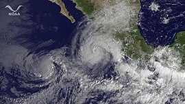
That same day, Adrian attained major hurricane status several hundred miles off the coast of Cabo Corrientes;[10] it peaked in intensity as a Category 4 storm shortly afterward, with sustained winds of 140 mph (225 km/h).
[11] For several hours, the hurricane exhibited what appeared to be an annular structure, maintaining an unusually large eye and symmetric central dense overcast.
As a result, eyewall replacement cycles were not expected to occur, and Adrian was forecast to remain well-organized and only slowly weaken in response to slightly cooler waters.
[12] However, the hurricane defied predictions and began devolving rapidly the next day, likely due to "an unexpectedly early increase of vertical wind shear coupled with marginal thermodynamics" as noted by the NHC.
On June 11, Adrian was downgraded to tropical storm status, recurving toward the west as a tight swirl of low-level clouds with little to no deep convection near its center.
[17] On June 14, the NHC noted a large area of scattered showers and thunderstorms associated with a monsoon trough over the east Pacific, several hundred miles from the coast of Acapulco, Mexico.
[18] A quasi-stationary surface low formed in association with the activity, and over the subsequent days convection consolidated in the vicinity of an anticyclone over the southwestern Caribbean.
[19] Curved rainbands began developing around the center, and on June 19 the system acquired sufficient organization to be classified as a tropical depression.
Turning toward the northwest along a weakness in the subtropical ridge to its north, the depression further strengthened within a favorable environment and was upgraded to Tropical Storm Beatriz at 1800 UTC that day, with winds of 40 mph (65 km/h).
Beatriz continued to strengthen and reached winds of 90 mph (145 km/h) and a pressure reading of 977 mbar (28.9 inHg) while it neared the coast of Mexico.
[30] The wave gained convection as it moved into the southwestern Caribbean, and the National Hurricane Center (NHC) began to monitor the disturbance, giving it a 10% chance of development into a tropical cyclone.
Slowly organizing, the low-pressure area had gained enough strength to be declared Tropical Depression Four-E during the morning hours of July 18.
Continuing west-northwestward, Fernanda began weakening late on August 18 as dry, stable air was entrained into its circulation and it encountered increasing south-southeasterly shear.
The post-tropical low continued westward before dissipating the next day a couple hundred nautical miles south of the Hawaiian Islands.
[42] The storm steadily intensified over 85 °F (29 °C) sea surface temperatures and it reached hurricane status late on August 17 with maximum sustained winds of 75 mph.
Late on August 24, the remnants of Hurricane Greg dissipated completely, far west of the southern tip of the Baja California Peninsula.
[47] The National Hurricane Center (NHC) began to monitor an area of disturbed weather southwest of the Mexican Riviera in late August.
[49] Thunderstorm activity become more concentrated two days later while located 60 mi (97 km) south of Zinhuatnejo, and the NHC noted that the disturbance could become a tropical depression within hours.
Over the next 3 days Hilary's remnant low subsequently moved towards the southwest, before dissipating after 1200 UTC on October 3, about 1,050 mi (1,690 km) to the west of the southern tip of Baja California.
Late on October 5, the National Hurricane Center (NHC) noted that the area had a high chance of developing into a tropical cyclone over the next 48 hours.
[62] A tropical wave, the same that spawned Hurricane Phillipe in the Atlantic, crossed Central America into the East Pacific on October 5, during a significant pulse of the MJO.
[66] The low remained over an area with favorable conditions for formation on November 18,[67] although convective activity tapered slightly later during the day as it began to curve west-northwestward.
[73] Rapid intensification continued and the storm was upgraded to a Category 4 hurricane with sustained winds of 145 mph, just a few hours later, as Kenneth reached its peak intensity.
[74] The cause for this rapid intensification just days before the end of the season was unclimatologically low wind shear as well as unusually warm waters directly in the storm's path.
However, Kenneth's intensification was short-lived; immediately it moved into an environment of colder waters and stronger wind shear, and started to rapidly deteriorate.