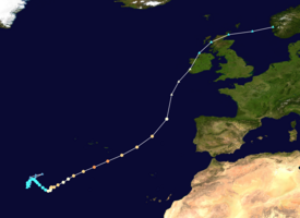
Hurricane Ophelia (2017)
Shortly after achieving peak intensity, Ophelia began weakening as it accelerated over progressively colder waters to its northeast towards Ireland and Great Britain.
[3] The system began to acquire subtropical characteristics on the next day, benefits from warm sea surface temperature of 27 °C (81 °F), thus the National Hurricane Center (NHC) noted for a high chance of tropical cyclogenesis.
[4] Although the system lost some of its organization due to dry mid-level air,[5] it managed to develop gale-force winds and a well-defined center.
[6] Deep convection continued to develop near the center early on 9 October,[7] and the NHC classified the system as Tropical Storm Ophelia at 06:00 UTC, about 1,410 km (875 mi) west-southwest of the Azores.
[3] Despite moving over marginally warm waters of 26.5 °C (79.7 °F), the effects of cold air temperatures aloft and decreasing wind shear allowed Ophelia to gradually strengthen.
[12] After developing a ragged eye,[13] the NHC upgraded Ophelia to a hurricane at 18:00 UTC about 1,225 km (760 mi) south of the Azores.
[15] Ophelia achieved its initial peak intensity at 06:00 UTC on 13 October, with maximum sustained winds of 169 km/h (105 mph) and a central pressure of 966 mbar (966 hPa; 28.5 inHg).
[18] Its eye became better defined, and the NHC upgraded Ophelia to a Category 3 hurricane at 12:00 UTC on 14 October; at 27.7°W, this was the farthest east that a storm of such intensity had been observed in the satellite era.
[19] It attained its peak intensity simultaneously with maximum sustained winds of 185 km/h (115 mph) and a central pressure of 959 mbar (959 hPa; 28.3 inHg) while located approximately 925 km (575 mi) southwest of the Azores.
Afterwards, Ophelia's extratropical remnants tracked over Ireland and made its second landfall in Soay, Inner Hebrides with winds of 97 km/h (60 mph), at 23:45 UTC.
The storm made its third and final landfall in Våge, Austevoll, with winds of 72 km/h (45 mph), at 17:30 UTC, before dissipating over Norway early on 18 October.
[22] An orange gale warning was issued for the eastern group for the afternoon through night of 14–15 October,[22] as well as a yellow alert for high seas.
[33] On 15 October, the National Emergency Coordination Centre and Met Éireann convened to advise the public in relation to the post-tropical storm reaching Ireland.
[38] All public transport previously scheduled within the red alert zone were cancelled including bus, rail and ferry journeys.
[46] Two men died in separate incidents after suffering fatal injuries while carrying out repairs to damage caused by Ophelia and Storm Brian.
[50] The Met Office in the United Kingdom issued the first severe weather warnings for Ophelia on 12 October, referring to the hurricane as "ex-Ophelia" in the context of the 2017–18 UK and Ireland windstorm season.
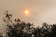
"We looked at photos from satellites and the Finnish weather service confirmed that the smoke and soot of the fires in Portugal and partly the dust from the Sahara reached us," meteorologist Taimi Paljak said.
Tropical storm (39–73 mph, 63–118 km/h)
Category 1 (74–95 mph, 119–153 km/h)
Category 2 (96–110 mph, 154–177 km/h)
Category 3 (111–129 mph, 178–208 km/h)
Category 4 (130–156 mph, 209–251 km/h)
Category 5 (≥157 mph, ≥252 km/h)
Unknown