2016 Pacific hurricane season
Finally, in late November, Hurricane Otto from the Atlantic made an unusual crossing over Central America, emerging into the East Pacific as a moderate tropical storm but dissipated shortly after.
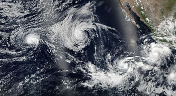
A powerful and long-lived westerly wind burst — a feature commonly associated with strong El Niño events — spurred cyclogenesis within a persistent low-latitude, west-to-east oriented surface trough, resulting in the formation of an area of low pressure on January 6.
[10] Steady weakening continued through January 9 as Pali's deep convection was displaced to the west of its low-level center and intermittently pulsed, later leading to a dramatic decrease in intensity.
[10] By the end of that day, Pali barely maintained tropical storm strength, and the lack of persistent deep convection permitted it to be less affected by the easterly wind shear, causing its forward motion to decrease significantly.
[10] As the ridge weakened and retreated southward on January 10, causing vertical wind shear to gradually diminish, Pali started re-intensifying, with persistent deep convection redeveloping near its center and within its western quadrant.
[10] On January 11, the ridge passed directly over Pali, leading to the reestablishment of poleward outflow and eventual development of southwesterly flow, enabling its convection to slowly increase in coverage and organization within all quadrants and establishing a northeastward movement.
[10][12] During the next few days, Pali rapidly weakened while turning back towards the south-southeast, due to steady increases in southerly vertical wind shear and loss of Coriolis force.
[34] Intensification stalled for the remainder of that day as dry air wrapped into the circulation;[35] however, Blas began to rapidly deepen on July 5, and it became the first major hurricane of the season that evening.
[48] The newly formed cyclone initially struggled to intensify with upwelling resultant from Hurricane Blas,[49] but a formative central dense overcast and several spiral bands prompted an upgrade to Tropical Storm Celia by 15:00 UTC on July 8.
[93] Progressively cooler waters and a more stable environment, however, caused Georgette to begin weakening soon thereafter: it fell below hurricane intensity by 15:00 UTC on July 26 and further degenerated into a remnant low well west-southwest of Baja California a day later.
[96] A large mass of convection developed south of Acapulco, Mexico two days later,[97] eventually coalescing into the record-tying eighth tropical cyclone to form in the East Pacific during the month of July.
[100] Continuing on its west-northwest path, Howard entered cooler waters and a more stable environment, and the combination of the two factors caused the cyclone to degenerate into a remnant low well west of Baja California by 21:00 UTC on August 3.
[102] A broad area of low pressure formed south of Manzanillo, Mexico two days later,[103] eventually gaining ample organization to be declared a tropical depression by 21:00 UTC on August 2.
[106] Continued wind shear and a more stable environment caused Ivette to weaken to a tropical depression by 03:00 UTC on August 8 as it entered the Central Pacific;[107] 18 hours later, the system degenerated into a remnant low well east of Hawaii.
[108] On August 2, the NHC noted that an area of low pressure in association with the remnants of Hurricane Earl could further develop into a tropical cyclone off the southwestern coastline of Mexico over subsequent days.
[109] An area of disturbed weather formed south of the Gulf of Tehuantepec two days later,[110] eventually acquiring sufficient organization to be declared a tropical depression by 06:00 UTC on August 7.
The outer rainbands from Lester produced heavy showers and minor flooding over the leeward slopes of the Big Island and portions of east Maui on September 3.
[citation needed]On August 21, the NHC noted that an area of low pressure could form well south-southwest of the southern tip of Baja California over subsequent days.
[147] A circulation began organizing within the system,[148] leading to the NHC classifying it as Tropical Depression Fifteen-E late on September 4 about 220 mi (355 km) southwest of Manzanillo, Colima.
[149] With warm waters, moderate wind shear, and adequate moisture, the system continued to organize after formation,[149] strengthening to Tropical Storm Newton by early on September 5.
[160] Passing south of the Gulf of Tehuantepec, the disturbance gradually organized, and by September 10, satellite images showed that a surface circulation has formed, however, thunderstorm activity was too disorganized to be classified as a tropical cyclone.
It is estimated that Tropical Depression Sixteen-E formed at 00:00 UTC on September 11 about 700 miles (1,100 km) south-southwest of the southern tip of Baja California, after curved banding features developed near the center.
[160] Trailing deep tropical moisture from the remnants of Orlene passing north of the island chain produced moderate to heavy rainfall and minor flooding along the windward slopes of Haleakalā on September 23.
[161] As fast as it became a hurricane, it weakened at a similar pace due to decreasing sea surface temperatures, and Paine degraded into a remnant low only a day after reaching its peak intensity.
The hurricane later entered a period of rapid intensification due to very favorable conditions, which included low wind shear, a moist atmosphere, and sea surface temperatures (SSTs) of around 29–30 °C (84–86 °F).
By late on October 25, Seymour reached its peak intensity as a high-end category 4 major hurricane with sustained winds of 150 mph (240 km/h) and a pressure of 940 millibars (28 inHg).
Shortly after peaking in intensity, the cyclone rapidly weakened in response to increasing wind shear, drier air and decreasing sea surface temperatures due to upwelling as it turned northwestwards around the edge of a subtropical ridge.
Continuing to move westwards due to the influence of a subtropical ridge to its north, Otto eventually encountered more hostile environmental conditions, as wind shear began to increase dramatically.
[169] On August 11, the Japan Meteorological Agency (JMA) reported that a tropical depression had developed near the International Date Line about 2,000 km (1,245 mi) to the northwest of Honolulu, Hawaii.
[171] On September 12, the JMA had reported that another tropical depression had developed east of the International Date Line,[172] while the CPHC assessed it as having a low chance of formation in the next 48 hours.