Tropical cyclones in 2016
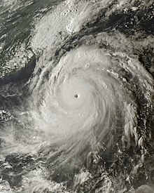
The strongest storm of the year was Winston, peaking with a pressure of 884 hPa (26.10 inHg) and with 10-minute sustained winds of 285 km/h (175 mph) before striking Fiji.
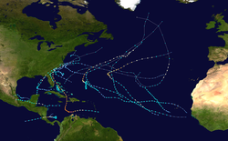
[1] The costliest and deadliest tropical cyclone in 2016 was Hurricane Matthew, which impacted Haiti, Cuba, Florida, Georgia and the Carolinas, causing US$15.09 billion in damage.
The accumulated cyclone energy (ACE) index for the 2016 (seven basins combined), as calculated by Colorado State University (CSU) was 806.5 units.
[12][13] During May 2016, the El Niño event dissipated as near to below average sea surface temperatures, expanded across the eastern equatorial Pacific Ocean.
As a result of this the BoM, NOAA's CPC, IRI, and the JMA, all declared that the record-tying El Niño event had ended in late May/early June.
Most significantly, one of the strongest El Niño events recorded in history rapidly dissipated, transforming to cool-neutral conditions across the Pacific in late summer.
Steering currents had also been different from past years, which had previously had a trough of low pressure dominating the East Coast of the United States.
[27] September featured another five tropical cyclones: Ian, Julia, Karl, Lisa, and Matthew, the latter of which persisted into October.
Javier and Newton followed similar paths close to the Mexican coast, with both making landfall in the Baja California Peninsula in August and early September respectively.
Hurricane Ulika became the first tropical cyclone on record to cross 140°W three times; it also became the first named storm in the Central Pacific basin since Pali back in January.
In late November, Tropical Storm Otto entered the basin from the Atlantic, becoming only the eighteenth cyclone to do so; however, it dissipated quickly due to unfavorable conditions.
[34] Nepartak reached Category 5 super typhoon intensity before making landfall in Taiwan and East China, causing a total of US$1.52 billion of damage.
In late July, Tropical Storm Mirinae reached its peak intensity while making landfall over Red River Delta in Northern Vietnam.
Later, Nida reached near typhoon strength; it affected the Philippines, South China and Vietnam, but its damage was lower than that of Mirinae.
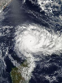
[35] Lionrock was a large, powerful, long-lived and erratic tropical cyclone which caused significant flooding and casualties in North Korea and Japan in late August.
Rai became a weak tropical storm before it made landfall in Vietnam, Laos and Thailand in mid-September, causing flooding and moderate damage.
[36] A tropical depression formed east of the International Date Line on October 3, and entered the basin before developing into Typhoon Songda.
[37] Severe Tropical Storm Aere affected parts of Southeast Asia in mid-October, including the worst flooding in Vietnam since 2010, causing a total of US$209 million of damage.
In late December, Nock-ten became the strongest Christmas tropical cyclone on record anywhere in the world since at least 1960 in terms of 1-minute sustained winds, before impacting the Philippines.
The beginning of June witnessed no storms, although many low-pressure areas formed over Bay of Bengal, but none of them intensified into a depression, due to a very strong southwest monsoon.
July witnessed no storms until a deep depression formed in August, under the influence of an upper air cyclonic circulation over Gangetic West Bengal.
[47][48] This low activity was partially attributed to the 2014–16 El Niño event, which caused systems to be displaced eastwards into the South Pacific tropical cyclone basin.
Stan subsequently made landfall on Western Australia and impacted various commodities including oil, natural gas, and iron ore.
Over the next few days, the system remained over water and dissipated during 15 February after it had produced some powerful, long period swells along Queensland beaches.
Specifically one of the storms that formed during the July-December season of the Australian region was that of Tropical Cyclone 02S, which was originally observed by NASA's GPM team.
This was attributed to a number of factors, including a poorly organised South Pacific convergence zone and a predicted La Niña episode not developing.
On 5 January 2016, the Hydrographic Center of the Brazilian Navy issued warnings on a subtropical depression that formed east of Vitória, Espírito Santo.
[58] Later, it intensified quickly and then transitioned into a subtropical storm shortly before 22:00 BRST (00:00 UTC on 5 December), with the name Eçaí assigned by the Hydrographic Center of the Brazilian Navy.
[citation needed] January was above average activity in terms of systems formed, with six tropical cyclones, of which five were named.
In the North Indian Ocean, Roanu caused severe impacts to Sri Lanka, India, Bangladesh, Myanmar, and Yunnan.