Interstate 90
It begins in Seattle, Washington, and travels through the Pacific Northwest, Mountain West, Great Plains, Midwest, and the Northeast, ending in Boston, Massachusetts.
It then traverses the northern Great Plains and travels southeast through Wisconsin and the Chicago area by following the southern shore of Lake Michigan.
I-90 was numbered in 1957, reflecting its status as the northernmost transcontinental route of the system, and construction was underway on several sections with funding from the Federal-Aid Highway Act.
The final section, near the western terminus in Seattle, opened in September 1993; an eastern extension in Boston was completed in 2003 as part of the Big Dig project.
[3][4] From the Wisconsin–Illinois state line to Massachusetts, approximately 760 miles (1,220 km) of I-90 uses turnpikes and other tolled highways with the exception of segments in Chicago, northeastern Ohio, Pennsylvania, and Albany, New York.
[7] The freeway travels east through an interchange with I-5 and around Beacon Hill before it enters the Mount Baker Ridge Tunnel alongside the future 2 Line of the Link light rail system, set to open in 2025.
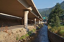
[8][10] The floating bridges cross Lake Washington to Mercer Island, where I-90 travels through a series of tunnels under 14 acres (5.7 ha) of parkland, including Aubrey Davis Park.
After traveling east across Moses Lake and the surrounding agricultural region, I-90 begins a long concurrency with US 395 at Ritzville as the highways turn northeast towards Spokane.
[4][16] The freeway continues east across Fourth of July Summit and descends into the Silver Valley, where it follows the Coeur d'Alene River through several small towns along the historic Mullan Road.
I-90 serves the cities of Kellogg and Wallace before it ascends into the Bitterroot Range and crosses Lookout Pass, which also marks the Montana state line.
The freeway continues into the Bear Lodge Mountains (part of the Black Hills) and is rejoined in Sundance by US 14, which looped north to serve the Devils Tower.
[29] It then skirts the northern edge of Rapid City, which is served by spur route I-190, and passes Ellsworth Air Force Base while it continues east across the plains.
[35] From the South Dakota border near Beaver Creek to Albert Lea, the freeway travels east across farmland and towns in the plains and rolling hills of the Buffalo Ridge.
It enters the state from Beloit, Wisconsin, and remains concurrent to I-39 and US 51 on the Jane Addams Memorial Tollway through the eastern outskirts of Rockford, where the highways split off.
[41] The freeway, now named the Kennedy Expressway, travels through northwestern Chicago, where the Blue Line of the "L" rapid transit system runs in the median and serves several stops.
[42] I-90 turns southeast and is rejoined by I-94 in Irving Park, where it gains a set of reversible express lanes that travel for 6.2 miles (10.0 km) toward the Near West Side.
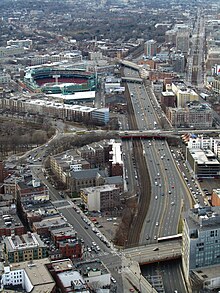
[45][46] I-90/I-94 is joined by the "L" Red Line in the median of the expressway through the city's South Side,[42] where it passes Rate Field, the Illinois Institute of Technology campus, and Washington Park.
[48] From the Illinois state line, the tollway travels south through Hammond and turns east to follow the Grand Calumet River through northern Gary, where it intersects US 41 and US 12.
The highways enter the Buffalo area, where the toll road runs north–south through Cheektowaga and forms an eastern bypass, using auxiliary routes I-190 and I-290 to serve the city.
[4][53] At a junction with I-290 near Buffalo Niagara International Airport, I-90 turns east to follow the historic Water Level Route of the New York Central Railroad, itself parallel to the 19th-century Erie Canal.
The freeway travels south around Rensselaer and rejoins the Thruway via the Berkshire Connector, which continues east into the Taconic Mountains toward the Massachusetts state line.
It serves as the respective northern and western terminus of I-395 and I-290 in Auburn, located southwest of Worcester, and continues to an interchange with I-495 near Westborough at the edge of Greater Boston.
[61] The section between I-93 and the airport was opened in the early 2000s as part of the Big Dig megaproject,[64] which rebuilt several Boston freeways and extended I-90 by 3.5 miles (5.6 km).
[3][65] An east–west controlled access highway to serve the Northern United States was proposed in the early 20th century in several federal government documents, including reports from the Bureau of Public Roads in the 1930s and 1940s.
[69][70] The freeway would travel along existing parts of the United States Numbered Highway System, which was established at the suggestion of the federal government in 1926 to replace the named auto trails.
[110][111] South Dakota completed its final section in November 1976, which created an unbroken stretch of four-lane highway from the Wyoming state line to Boston but some intersections remained.
[121] The viaduct replaced an earlier plan for a ground-level freeway at the behest of environmentalists; the Mountains to Sound Greenway was established in 1990 along the corridor between Seattle and Thorp to preserve wilderness and recreational areas and was designated as a National Scenic Byway in 1998, a first for an Interstate Highway.
[124] The project involved construction of a new floating bridge, expansion of the Mount Baker Ridge Tunnel, addition of lids with parks, and extensive mitigation for environmental and social impacts.
The west end at Washington State Route 519 in Seattle was rebuilt as a series of ramps near Safeco Field (now T-Mobile Park) to replace an existing intersection.
The 11-mile (18 km) Dan Ryan Expressway in Chicago was reconstructed over a two-year period from 2006 to 2007 at a cost of $975 million (equivalent to $1.38 billion in 2023 dollars),[117] adding auxiliary lanes and improved bridges.