India Basin, San Francisco
[2]: 13 The name India Basin was first given in 1868 by the State Board of Tide Land Commissioners, defined as the area between the mouth of Islais Creek and the eastern end of Hunters Point.
[6] Contemporary coverage indicates this did not occur as intended, describing water "black with decomposed blood, [bearing] on its surface masses of foul straw, stable ordure and floating offal"[7] with a smell that reportedly caused a traveler to return on the Oakland ferry without bothering to disembark.
[8] The southern part of India Basin (centered along 9th Avenue South, now Innes) also was used by small boat builders, starting in approximately 1870, drawn from Islais Creek and Potrero Point by inexpensive land and deep Bay water access.
[2]: 2 Plans were prepared after the 1906 San Francisco earthquake to build houses on land to be reclaimed from the Bay by fill, but voters in Los Angeles defeated the proposed bond which would have funded a seawall.
[9]: 4–5 In 1969, the Port of San Francisco voted unanimously to approve plans to construct a new 50-acre (20 ha) lighter aboard ship (LASH) terminal for Pacific Far East Lines on the new fill.
[13]: 4, 7 By 1975, more than $22 million had been spent to remove and bulldoze the remaining slaughterhouses and automotive wrecking yards in the area, but none of the new lots had been sold,[14] and backers began to market the site to the United States Postal Service (USPS).
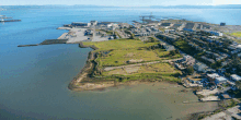
It is just north of the Bayview neighborhood, and south of the Pier 90–96 cargo terminal, which includes the LASH shipping facility built originally by the Port of San Francisco for Pacific Far East Lines.
[23] Seattle-based landscape architecture firm GGN (Gustafson Guthrie Nichol) won the competition, focusing their proposal on a softened shoreline and connections to the existing neighborhood.