Jackson Plan
Upon his final return to colony in October 1822, Raffles was displeased by the disorderliness of the town and that Farquhar had not followed closely the instructions he gave.
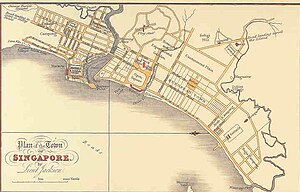
They were assisted by Lieutenant Philip Jackson who drew up the layout plan of the city according to Raffles' instructions.
[1][7] It has been observed by the Supreme Government "that in the event of Singapore being permanently retained, there seems every reason to believe that it will become a place of considerable magnitude and importance, and it is essential that this circumstance should be constantly kept in mind, in regulating the appropriation of land.
Every day's experience shews that the inconvenience and expense that may arise out of the want of such a forecast" and in this respect an economical and proper allotment of the ground intended to form the site of the principal town is an object of first importance, and one which under the present circumstance of the Settlement will not admit of delay.
[2] The committee consulted representatives from the Malay, Chinese, Bugis, Javanese, and Arab communities on the proposed resettlement of the population into their respective areas.
[7] The plan was drawn up some time in December 1822 or January 1823, and it was first published in an article by John Crawfurd as an engraving made in June 1828.
[2] The plan is an idealised scheme of how Singapore may be arranged; the streets of the colony were laid out for the large part in a grid pattern, but taking into account the curves of the seashore and rivers as well as the topology of the hills.
[9] The area west of South Bridge Road was still an undeveloped marshy land in a survey conducted by Coleman in 1829 and published in 1836,[2][10] but had built up according to the maps of John Turnbull Thomson from 1846.
This proposal produced the distinctive five foot ways of the local architecture of Singapore and Malaysia where by-laws were enacted requiring such walkways, and it also spread to other countries including parts of Thailand and the Philippines as well as Taiwan, Hong Kong and the port cities of southern China.